|
PLANNING COMMISSION REPORT Regular Agenda - Public Hearing Item |
|
ITEM NO.4: Z-15-00463 RM12D to RS7 and OS; 11.855 acres; 5800 Overland Drive (BJP)
Z-15-00463: Consider a request to rezone approximately 11.855 acres from RM12D (Multi-Dwelling Residential) District to RS7 (Single-Dwelling Residential) District and OS (Open Space) District, located at 5800 Overland Dr. Submitted by Grob Engineering Services, LLC on behalf of Oregon Trail Holdings, LC and the City of Lawrence, property owners of record.
|
|
|
STAFF RECOMMENDATION: Staff recommends approval of the request to rezone approximately 11.80 acres, from RM12D (Multi-Dwelling Residential) District to RS7 (Single-Dwelling Residential) District and 0.055 acres from RM12D (Multi-Dwelling Residential) to OS (Open Space) District based on the findings presented in the staff report and forwarding it to the City Commission with a recommendation for approval. |
|
|
Reason for Request: |
“Originally believed that multi-family would be best for this area which was before Rock Chalk Park was developed. With the construction of Rock Chalk Park and Sports Pavilion Lawrence, the market is for single-family dwellings.”
|
|
KEY POINTS · The intent of this proposal is to rezone approximately 11.80 acres to RS7 District, and approximately 0.055 acres to OS District. The request to rezone to accommodate single-family zoning is prompted by the changes in the housing market, while rezoning to OS will provide consistency with adjacent property. |
|
|
ASSOCIATED CASES/OTHER ACTION REQUIRED · MS-15-00546: Minor Subdivision at 5800 Overland Drive and George Williams Way, currently being administratively processed. |
|
|
PLANS AND STUDIES REQURIED · Traffic Study – Not required for rezoning · Downstream Sanitary Sewer Analysis – Not required for rezoning · Drainage Study – Not required for rezoning · Retail Market Study – Not applicable to residential request |
|
|
PUBLIC COMMENT RECEIVED PRIOR TO PRINTING · None |
|
Project Summary:
The subject area is located east of George Williams Way and north of Overland Drive. The proposed request is for the rezoning of approximately 11.80 acres within the Oregon Trail Addition to accommodate single-family development. The rezoning request stems from a change in the housing market and the development of the Rock Chalk Park. A minor subdivision application is currently being administratively processed. The subject property was previously platted with 37 lots at RM12D. The proposed replat would reduce the density to 51 lots at RS7.
The rezoning request also includes a proposal to rezone approximately 0.055 acres from RM12D to the OS District. This area is located between George Williams Way and Three Forks Drive and contains a 20’ utility and access easement. This area is identified as Tract B on the Oregon Trail Addition 2nd Plat. This easement extends to the east of Three Forks Drive and ties into Tract A, which is zoned OS (Open Space) District. Rezoning Tract B to OS District would align the zoning of that property with that of the adjacent Tract A.
|
|
|
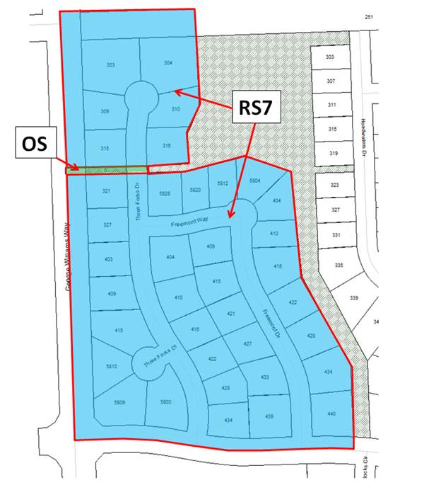
Figure A: The 11.80 acre area requested to be rezoned to RS7 is shown in blue, and the 0.055 acre area requested to be rezoned to OS is shown in green. |
1. CONFORMANCE WITH THE COMPREHENSIVE PLAN
Applicant’s Response: “Single-family guide to placement is stable, safe, and pleasant neighborhoods. The adjacent property is zoned RS7 and down zoning this property would generally meet the criteria in Horizon 2020 with close proximity to RCP.”
The subject property was annexed into the City in 2001 to facilitate the City’s financing of a W. 6th Street/US 40 improvement project. As part of the annexation, an agreement was made that the property would retain the Douglas County zoning designation of A (Agricultural) District until development was proposed. On November 16, 2004, the City Commission approved a request (Z-09-48-04) to rezone the subject property from A District to RM-D (Duplex Residential). The intent of the 2004 rezoning request was to provide an area for residential population growth. There were two other zoning requests submitted concurrently (Z-09-46-04, Z-09-47-04), which requested rezoning the surrounding area to single-family and multi-family zoning districts.
Chapter Five of Horizon 2020, Residential Land Use, discusses the strategies for residential development. One of the principal strategies given states, “A mixture of housing types, styles and economic levels should be encouraged for new residential and infill developments”. There are multi-family zoning districts located to the north and south of the subject property, as well as a single-family zoning district to the east. If the subject property were rezoned to RS7, a mixture of housing types would still be available in the immediate area.
Horizon 2020 also states, “Low-density residential development, reflecting a density of six or fewer dwelling units per acre, would continue to be the predominant land use in the city. While this classification includes densities that would encompass duplex and some townhouse development, emphasis is placed on single-family detached development.” This rezoning request aligns with that objective.
Regarding open space, Horizon 2020 encourages the development of a comprehensive network of open spaces that connect neighborhoods and recreational opportunities. Tract B exists in that capacity. Future development of Tract B will include an extension of the existing multi-use trail. This improvement will provide a pedestrian connection to the existing green space to the east and the Rock Chalk Park to the west.
Staff Finding – The proposed request represents a low-density residential development pattern and recreational amenities that are consistent with the land use recommendations in Horizon 2020.
2. ZONING AND USE OF NEARBY PROPERTY, INCLUDING OVERLAY ZONING
|
Current Zoning and Land Use: |
RM12D (Multi-Dwelling Residential) District; Undeveloped. |
|
|
Surrounding Zoning and Land Use: |
North: |
RM12-PD (Multi-Dwelling Residential with a Planned Development Overlay) District; Undeveloped – development plans for Multi-Dwelling development with accessory golf course have preliminary approval.
GPI; Rock Chalk Park, General Entertainment and Spectator Sports, Active Recreation, Passive Recreation.
|
|
East: |
OS (Open Space) District; Detention pond and multi-use trail.
RS7 (Single-Dwelling Residential) District; Undeveloped.
|
|
|
South: |
RM12 (Multi-Dwelling Residential) District; Undeveloped.
|
|
|
West: |
CC600 (Community Commercial) District; Undeveloped – development plans for commercial development as part of the Mercato development have preliminary approval. |
|
|
|
|
|
|
|
|
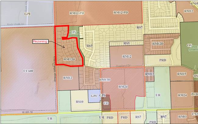
Figure B: Surrounding zoning of the subject property. |
Staff Finding – As proposed, the subject property will be uniformly zoned similar to development property located to the east.
3. CHARACTER OF THE NEIGHBORHOOD
Applicant’s Response: “The property to the north and south is medium density multi-family dwelling and property to the east is the single-family. The property of the west is CC600 and no development has occurred there.”
The area is developing with a variety of uses. The subject property is located southeast of the Rock Chalk Park. In addition, single-family and multi-family neighborhoods are being developed to the north, east and south of the property. The property to the north is planned for a multi-family development that will include an accessory golf course. There is also commercial development planned for the area. The property to the west of the subject property is zoned CC600 and is currently undeveloped. However, this commercially zoned area is part of the Mercato development that has received preliminary approval.
Staff Finding – The proposed request is consistent with the developing character of the area and appears to meet a market-defined need for more individual residential lots.
4. PLANS FOR THE AREA OR NEIGHBORHOOD, AS REFLECTED IN ADOPTED AREA AND/OR SECTOR PLANS INCLUDING THE PROPERTY OR ADJOINING PROPERTY
The property is located within the boundary of the Northwest Plan, which was adopted by the City Commission on January 28, 1997. Specifically, the subject property is located in the section identified as 29 (Figure 3). The plan indicates this section is planned as an urbanized area, and that higher intensive land uses should be directed toward 6th Street and K10. Land uses lower in intensity are to be directed toward the north of sections 28 and 29. Furthermore, the plan states that single-family residential is encouraged in the central and northern parts of sections 28 and 29. Finally, the plan also states that “Further south, in the central portions of section 28 and 29, conventional single-family residential is planned. Multiple family residential land uses (duplex through multi-unit apartments) is primarily planned only in the southern portions of sections 28 and 29.”
|
|
|
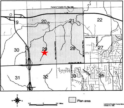
Figure 3: Map showing the Northwest Plan area, approximate location of subject property indicated by red star. |
Staff Finding – The proposed rezoning request is consistent with the applicable area plan.
5. SUITABILITY OF SUBJECT PROPERTY FOR THE USES TO WHICH IT HAS BEEN RESTRICTED UNDER THE EXISTING ZONING REGULATIONS
Applicant’s Response: “The RM12D is a suitable zoning for project location, but with changes in the surrounding area that have occur, the housing market shows a need for single-family residences in this area.”
The proposed zoning is for a land use that is a detached dwelling housing type located on individual lots. Detached dwellings are allowed in the RM12D District but require a Special Use Permit. This would be an onerous requirement for new development. The applicant’s intent is to modify the development pattern to provide more detached housing on smaller lots than previously approved. Therefore, the existing RM12D zoning is not suitable.
Staff Finding – The existing zoning is not suitable given the intended development pattern for this property.
6. LENGTH OF TIME SUBJECT PROPERTY HAS REMAINED VACANT AS ZONED
Applicant’s Response: “Over 5 years.”
As discussed previously, the subject property was rezoned from A District to RM-D District in 2004. On June 12, 2007, the City Commission approved Ordinance 8117 to convert the RM-D zoning to RM12D to align with the newly adopted 2006 Land Development Code. Development has not occurred on the property during that time period.
Staff Finding – The property has been zoned for multi-family since 2004.
7. EXTENT TO WHICH APPROVING THE REZONING WILL DETRIMENTALLY AFFECT NEARBY PROPERTIES
Applicant’s Response: “The rezoning will have no detrimental impact on nearby properties because there is RS7 zoning adjacent to the site within the Oregon Trail Addition. The proposed single-family residential is compatible in location and scope with the existing single-family and multi-family residences.”
The surrounding area will be developed with a variety of uses. There are multi-family and single-family zoned districts to the north, east, and south of the property. Rezoning the subject property to RS7 will provide consistency with the adjacent area to the east that is also zoned RS7.
Staff Finding – There are no anticipated detrimental effects for nearby properties.
8. THE GAIN, IF ANY, TO THE public health, safety and welfare due to the denial of the application, as compared to the hardship imposed upon the landowner, if any, as a result of denial of the application
Applicant’s Response: “The rezoning would be a down-zoning to less density single family dwellings and would provide more single-family lots for housing market. The rezoning would allow for immediate development, while remaining at RM12D zoning would see this property remain vacant for a longer period of time.”
Evaluation of this criterion includes weighing the benefits to the public versus the benefit of the owners of the subject property. Benefits are measured based on anticipated impacts of the rezoning request on the public health, safety, and welfare.
When the rezoning requests were approved for the subject property and the surrounding area, public improvements were provided with the extension of water, sanitary sewer, and stormwater lines. Other public improvements to the area included the extensions of Stoneridge Drive, Overland Drive, and George Williams Way.
Staff Finding – Approval of the proposed request facilitates residential development in an area planned for low-density residential development.
9. Professional staff recommendation
Staff recommends approval of the proposed rezoning of approximately 11.80 acres from RM12D District to the RS7 District and 0.055 acres from RM-12D to the OS District as they are appropriate zoning districts for the subject property.