Memorandum
City of Lawrence
Planning & Development Services
|
TO: |
Diane Stoddard, Interim City Manager |
|
FROM: |
Planning Staff |
|
DATE: |
July 28, 2015 |
|
RE: |
East Lawrence Neighborhood Zoning Options |
Background
The City Commission, on behalf of representatives of the East Lawrence Neighborhood, directed staff to review the zoning options available to potentially change the current zoning of a portion of the neighborhood. The desire is created from the recent development activity within the area, such as the newly constructed 9Del Lofts at 900 Delaware Street and the East Ninth community art and streetscape project. Landowners have expressed concerns that the area north of E 9th Street is not zoned appropriately for the existing use which could affect the residential neighborhood if future development occurs under the current RM24 zoning.
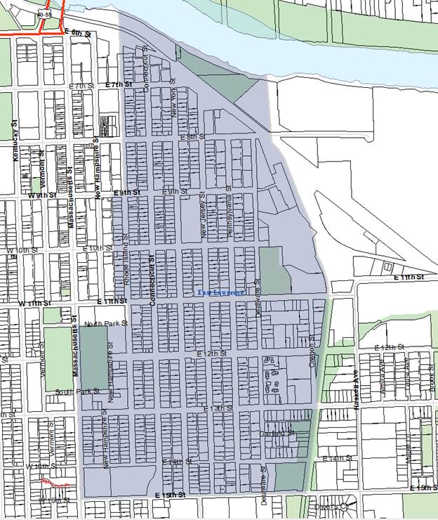
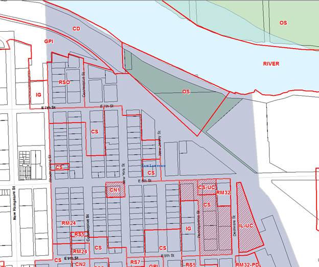
The boundaries of the East Lawrence Neighborhood are the Kansas River (north), Burroughs Creek trail (east), E 15th Street (south), and downtown (west) (Figure 1). The majority of the neighborhood is zoned for residential uses, with some CS (Commercial Strip) District zoning located within the neighborhood. The residentially zoned area north of E 9th Street is zoned RM24 (Multi-Dwelling Residential) District (Figure 2a). The RM24 District permits a variety of housing options, such as Attached Dwelling, Cluster Dwelling, Duplex, and Multi-Dwelling Structure. In this district, a Detached Dwelling is permitted with approval of a Special Use Permit. The area was developed prior to the adoption of the current Land Development Code and as a result contains multiple nonconforming uses. While the Detached Dwellings came into existence legally, they do not meet the standards of RM24 District zoning. Table 1 shows the number of Detached Dwellings, Duplexes, and Multi-Dwelling located in the RM24 District located north of E 9th Street based on County Appraiser data.
|
|
Total |
Percent |
|
Detached Dwelling |
89 |
75% |
|
Duplex |
24 |
20% |
|
Multi-Dwelling |
6 |
5% |
|
Total |
119 |
100% |
|
Table 1. Housing types in RM24 District north of E 9th Street. |
||
|
|
|
Figure 1. East Lawrence Neighborhood Boundaries |
|
|
|
Figure 2a. Zoning of Area North of E 9th Street in the East Lawrence Neighborhood. |
As shown in Figure 2b below, the area south of E 9th Street in the East Lawrence Neighborhood is primarily zoned RS5 District; however, this area consists of a variety of other zoning districts. The west boundary of the area contains RM12 and RM32 Districts. The east boundary contains IG (General Industrial), OS (Open Space), PRD (Planned Residential), GPI (General Public and Institutional Use), and small pockets of Multi-Dwelling Residential. The uses of the area south of 9th Street generally conform to their current zoning and this area has not been identified by the neighborhood as an area in need of rezoning.
|
|
|
Figure 2b. Zoning of Area South of E 9th Street in the East Lawrence Neighborhood. |
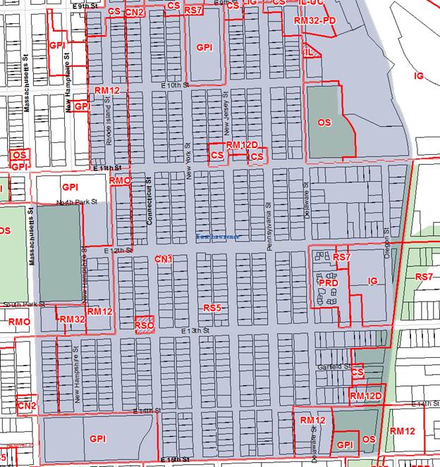
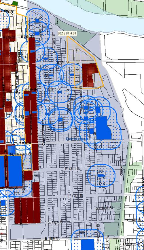
Figure 3 below shows the historic environs of the East Lawrence Neighborhood. The environs include properties within 250’ of properties listed on the Lawrence Register. Properties within the historic environs are subject to review by the Lawrence Historic Resources Commission when exterior construction, alteration or removal requires a city permit; or when demolition is proposed that requires a city demolition permit. No review is required for ordinary maintenance or repair of a structure or building, or for interior maintenance that does not require exterior alterations.
|
|
|
Figure 3. Historic Environs of the East Lawrence Neighborhood. |
Zoning Options
Below is a review of the zoning options available that could address the zoning concerns of the East Lawrence Neighborhood for the area north of E 9th St. Also provided are the processes needed to implement each option.
1. Rezoning (Downzoning)
Rezoning the RM24 District to a Single-Dwelling Residential District would be considered a downzoning due to the reduction in intensity of the zoning classification. Downzoning can be a tool used to preserve the character of the neighborhood as future development occurs and align nonconforming uses to an accommodating zoning district. Careful study is needed to identify which conforming uses would be made nonconforming with a rezoning effort.
PROCEDURE
This process can be initiated by the City Commission or the Planning Commission. The process will include a Planning Commission public hearing, of which the public is notified via newspaper and sign posting, and properties located with 200 feet of the proposed rezoning boundary receive mail notification.
Planning staff would review the rezoning request based on the criteria found in the Development Code and provide a report of findings to the Planning Commission and the City Commission. After the Planning Commission public hearing, the body will make a recommendation to the City Commission to approve, approve with conditions, or deny the rezoning request. A protest petition may be submitted within 14 days of the conclusion of the Planning Commission’s public hearing. To be considered valid, a protest petition would need to contain signatures of a minimum of 20% of the property owners within the proposed rezoning boundary, or a minimum of 20% of property owners surrounding the boundary. Following the 14 day waiting period, the City Commission will receive the Planning Commission’s recommendation and will then take an action on the request. If approved, the rezoning would become effective upon publication of the adopting ordinance.
Per Section 20-1303(g) of the Development Code, the criteria for review and decision making includes conformance with the Comprehensive Plan, the zoning and use of the nearby properties, the character of the neighborhood, the plans for the area, the suitability of the request, the effect of the change to the nearby properties, and the gain to public health, safety and welfare.
2. Urban Conservation Overlay District
Section 20-301 of the Development Code defines an overlay district as a “tool for dealing with special situations or accomplishing special zoning goals.” Overlay Districts are placed on the base district classifications to alter the regulations of the base district. As a tool for the area north of E 9th Street in the East Lawrence Neighborhood, an Urban Conservation Overland District (UCO) could be considered. This zoning tool may address the concerns of the landowners by encouraging development that conforms to the size, orientation and setting of existing buildings in the neighborhood. It can also foster development that is compatible with the scale and physical character of the original buildings in the neighborhood through the use of Development/Design Standards and guidelines. At this time, the city has two UCO districts (Downtown and 8Th & Pennsylvania Street) and is processing one for the Oread Neighborhood.
Per Section 20-308(b), to be eligible for UCO zoning, the area shall have been established 25 years prior to the adoption of the Development Code, have a general pattern of development, possess built environment characteristics that create an identifiable setting, and be a contiguous area of at least 5 acres in size. In staff’s opinion, the area north of E 9th Street meets these criteria.
PROCEDURE
UCO Districts can be initiated by the Historic Resource Commission (HRC), the Planning Commission, or the City Commission. Applications may also be initiated by a petition when the document is signed by owners of at least 51% of the area within the proposed UCO District or by 51% of the total number of landowners within the proposed district.
The HRC and the Planning Commission will hold public hearings on the UCO zoning application and its accompanying design guidelines prior to consideration by the City Commission. The design guidelines can take many months to complete and educating property owners on their use is an important component of creating them. Similarly to the rezoning procedure, the public and property owners will be notified via newspaper notice, signs, and mail. The HRC will review the application in relation to the selection criteria of Section 20-308(b) and submit a report and a recommendation to the Planning Commission. That body will then make a recommendation to the City Commission to approve, approve with conditions, or deny the application. The City Commission will make the final determination on the item.
Discussion
When considering which, if any, of the zoning tools would be best to use, it is important to consider the circumstances of the neighborhood and which tool would benefit the neighborhood the most. Considering the concerns expressed by property owners within the neighborhood and the existing single-family residential uses of the area, downzoning may be the most appropriate tool to rezone the area within the neighborhood that is currently zoned RM24. Rezoning to a Single-Dwelling Residential District could align the current uses to a more compatible zoning, as well as facilitate future development that is consistent with the existing development in the neighborhood. In staff’s opinion, the UCO is not necessary if the area is rezoned to an RS District, unless it is believed that design guidelines are necessary to ensure compatible development.
Action Requested
Direct Staff as appropriate.