Memorandum
City of Lawrence
Planning & Development Services
|
TO: |
Lawrence Douglas County Metropolitan Planning Commission
|
|
FROM: |
Planning Staff
|
|
Date: |
May 20, 2015
|
|
RE: |
Inverness Park Area Development History
|
Attachments: A—Inverness Park District Boundary Map
This memo provides a brief summary of land use for the area included in the Family Fun Center development applications (Z-13-00483, SUP-13-00486 and SUP-14-000026). The subject property proposed for CN2 zoning is part of an area known as Inverness Park. This area is also included in the Inverness Park Area Plan. The Plan was developed in response to several development applications for medium density residential uses on the remaining undeveloped land in Inverness Park. It was initiated in 2010 and approved in the fall of 2011. The Plan was then revised and approved by the City Commission in June 2012.
The history of development applications is provided below. This includes a summary of the distinct areas located within the original 160+ acre Inverness Park area. Following this description is a timeline identifying the various development proposals and rezoning actions that have occurred over the past 15 years in this area.
History
An annexation request for 163 acres was approved in 1999. The development application included multiple rezoning requests. Large tracts were platted along Clinton Parkway and zoned RO-1B for the most intensive part of the development of the 163 acres. The area south of W 24th Place but north of the open space/drainage area was designated as the transition area to the lower density, detached residential home lots to the south. The area south of W 24th Place was zoned PRD-2 with a maximum density of 12 dwelling units per acre. W 24th Place was designed to provide access to all lots in the area with access prohibited to Clinton Parkway as well as limitations placed on Inverness Drive and Crossgate Drive.
The preliminary plat for the entire 163 acres was approved in October 1999, and later revised in February 2001. The revisions affected the single-family area by reducing lot size and creating more lots than the original approval. The large lot configuration along Clinton Parkway and W 24th Place did not change. The preliminary plat served as the master plan for the development of the site. It provided the basic boundary of the various zoning districts planned for the 163 acres.
Much of the original land use discussion focused on the need to provide adequate public facilities such as streets and other infrastructure, as well as the land use scheme and transition through the entire acreage included in the Inverness Park Addition. At the time only the area on the west side of Inverness Drive was developed with single-family uses.
Multiple land use decisions made since 1999 have resulted in deviations in the land use pattern first proposed for the original 160 acre plan. The location of boundary streets isolates the remaining undeveloped property from connectivity with the larger surrounding neighborhood.
|
1999 Annexation Reqest
|
The area included requests for conventional detached single-family residential, duplex, office, planned commercial and planned residential zoning. The office zoning (21.63 acres) was located along the south side of Clinton Parkway adjacent to Inverness Drive. However, this zoning was withdrawn by the applicant in 1999.
Development of the area included subdivision approval that established the structure of the developing neighborhood. This included large lots along Clinton Parkway, an east--west street connection south of Clinton Parkway (W 24th Place) and large lots south of W 24th Place. The natural boundary for the higher-intensity uses in the north portion of the area was identified as the drainage area located in the central portion of the overall site and a tributary that runs north--south in the eastern portion of the property. The area south of the drainage way was platted and developed with low-density residential uses (single-family and duplex housing) between 1999 and 2002.
|
NORTHERN DEVELOPMENT – INVERNESS PARK PLAZA ADDITION NO. 1
|


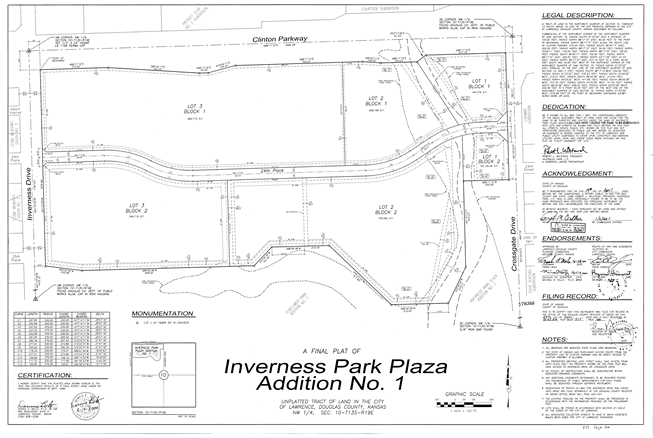
A - Clinton Parkway to 24th Place
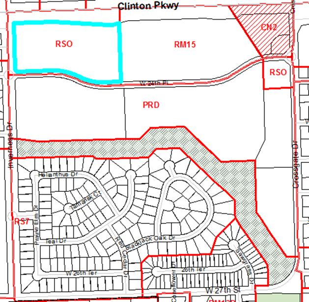
Zoning along the entire Clinton Parkway frontage, north of W 24th Place between Crossgate Drive and Inverness Drive, was zoned RO-1B prior to 2006. This district allowed a maximum density of 12 dwelling units per acre. Allowed uses included single-dwelling residential, multi-dwelling residential, and office uses. When the Land Development Code was adopted in 2006, this zoning designation converted to RSO. While still allowing office uses, RSO districts do not allow multi-dwelling uses. On December 19, 2007, the Planning Commission voted unanimously to recommend rezoning 15 acres of land along Clinton Parkway from RSO to RM15 as part of the Remington Square development. The City Commission approved the rezoning on March 11, 2008 via Ord. No. 8223.
B - 24th Place to the Open Space
The zone for the large lots along the south side of W 24th Place was approved as PRD-2 with a maximum gross residential density cap of 12 dwelling units per acre via Ord. No. 7170, which was approved by the City Commission on November 16, 1999. The property, at 4301 W 24th Place, The Grove, (aka Legends at KU Phase II) was rezoned via Ord. No. 7828. This zoning was approved by the City Commission on September 14, 2004 with a limitation on the maximum gross residential density to 13.7 dwelling units per acre. Special attention was paid to the development pattern along Inverness Drive. This section of the plan required a transitional building type and dense landscaping to buffer the development from the existing detached homes west of Inverness Drive.
The Legends at KU was the first multi-family development approved and constructed. This first phase included 16.88 acres and 200 units. A second phase of development was approved for preliminary development in the summer of 2004. Phase 2, which later became The Grove, included 12.5 acres and 172 apartments.
Three lots are located along Crossgate Drive south of W 24th Place. One lot at the corner of W 24th Place & Crossgate Drive is zoned RSO. The other two lots are currently zoned PRD-1. This zoning was approved in 1999 via Ord. No. 7169 and restricted residential development to not more than 10 dwelling units per acre. The southernmost lot is developed as Wyndam Place, a retirement facility.
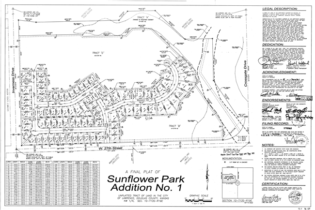
C - Open Space to 27th Street
The first section completed of the 160 acre development included the single-family lots south of the drainage easement. Several final plats were approved for the low density residential development including single-dwelling and duplex homes.
|
SOUTHERN DEVELOPMENT - SUNFLOWER PARK 27TH STREET OPEN SPACE
|


Residential Uses
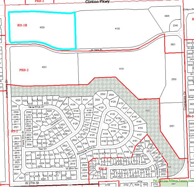
The original 1999 land use approvals for the 163 acres included residential and residential office uses. The intent of the zoning approval was to establish a transition of uses from north to south with the most intensive uses located closest to Clinton Parkway and the least intensive uses located closest to W 27th Street. The following graphic shows RO-1B zoning along Clinton Parkway, PRD-2 zoning along W 24th Place and along Crossgate Drive. The area south of the park area includes the RS-2 and RM-D district boundaries.
The southern portion of the original 163 acres developed consistently with planned low-density residential development. The southeast area was zoned and developed with duplex lots. The remaining southern area was developed in phases with detached single-family lots.
Commercial Uses
Commercial uses were not recommended at the intersections of Clinton Parkway & Crossgate Drive or Clinton Parkway & Inverness Drive prior to the adoption of the Inverness Park Area Plan in 2011. Previous plans including Horizon 2020 supported commercial development at specific nodes. Along Clinton Parkway, the commercial nodes designated in this area were at Kasold Drive and Wakarusa Drive.
Through the planning process and the development of the Inverness Park District Plan neighborhood commercial uses were identified as appropriate for the corners at Crossgate Drive and Inverness Drive. This use was identified by residents in the area as preferable to the existing residential zoning.
Timeline of Development Activity
1999-Annexation Request
163.46 acres bounded by Clinton Parkway on the north, Crossgate Drive on the east, W 27th Street on the south, and Inverness Drive on the west.
Multiple Rezoning Requests
Large tracts were platted along Clinton Parkway and zoned RO-1B for the most intensive part of the development of the 163 acres. The area south of W 24th Place but north of the open space/drainage area was designated as the transition area to the lower density, detached residential home lots to the south. The area south of 24th Place was zoned PRD-2 with a maximum density of 12 dwelling units per acre.
Preliminary Plat
The preliminary plat served as the master plan for the development of the site. It provided the basic boundary of the various zoning districts planned for the 163 acres.
2000-Silvercrest at Inverness
UPR-3-2-00/PDP-3-10-00, Special Use Permit/Preliminary Development Plan for assisted living/independent living senior housing development. Project never built.
2001-Revised Preliminary Plat
The revisions affected the single-family area by reducing lot size and creating more lots than the original approval. The large lot configuration along Clinton Parkway and W 24th Place did not change.
2002-The Legends at KU
FDP-2-1-02, Final Development Plan for multi-family residential development located along the south side of W 24th Place. This development was designed as a student oriented residential apartment complex.
2003-Wyndam Place
FDP-12-17-02, Final Development Plan for senior independent living units located along Crossgate Drive.
2004- The Fountains
UPR-9-9-04, a Special Use Permit, located along Clinton Parkway proposed a mixed residential retirement facility. The retirement project expired with conditions of approval not being met. The developer abandoned the project.
2008- Legends at KU -Phase 2
FDP-7-10-04/FDP-2-3-06, Final Development Plans approved for second phase approved, but not built.
2008- Minor Subdivision
Modified interior lot lines for lots along Clinton Parkway.
2008- Walgreens
Z-5-12-08, a rezoning request from RSO to CN2 at the southwest corner of Clinton Parkway & Crossgate Drive. The request was approved by the Planning Commission but was withdrawn by the applicant prior to the City Commission’s consideration of the item.
2009- The Grove
FDP-7-5-09, Final Development Plan for multi-family residential development revised Phase 2 of the Legends at KU with new owners was approved. This development was designed as a student oriented residential apartment complex.
2009-Remington Square
Development request for property located on the north side of W 24th Place that included a request to rezone to RM15 as well as a final plat and site plan for multi-family residential development.
2009- Clinton Parkway Casitas
SP-9-40-09, a site plan for an attached multi-family residential development located on the southeast corner of Clinton Parkway & Inverness Drive. The applicant withdrew the request in October 2009.
2010- W 24th Place Casitas
SP-1-2-10, a revised site plan for multi-family residential development submitted following public comment to address landscaping. This project was also withdrawn.
2010- Inverness Park District Plan Initiated
Plan initiated by the City Commission on November 9, 2010 after concerns raised by residents in the area about the proliferation of multi-family uses and the impact they were having in the area. Plan specifically focused on the remaining undeveloped parcels in the neighborhood.
2010- Remington Square
Rezoning request for property located on the north side of W 24th Place to increase in density from RM15 to RM24 to accommodate additional development on the east side of the property. The zoning request was denied.
2011-Hy-Vee Gas Station
Z-7-21-11, a rezoning request from RSO to CN2 and SUP-7-4-11, Special Use Permit for Hy-Vee gas station with future carwash for the southwest corner of Clinton Parkway & Crossgate Drive.
2011- Inverness Park District Plan Approved
Plan approved October 2011.
2011- Crossgate Casita
FPD-11-11-10, Final Development Plan for attached multi-family residential development located north of the senior living facility along Crossgate Drive.
2012- Revised Inverness Park District Plan Approved
Plan revised to provide additional land use guidance for undeveloped portion of Remington Square and approved June 2012.
2012-Minor Subdivision
A minor subdivision was approved, which subdivided the lot on the southwest corner of Clinton Parkway & Crossgate Drive for the Hy-Vee gas station. This division created two commercial lots at the corner.
2013- Family Fun Center
Z-13-00483, rezoning request from RSO to CN2; SUP-13-00486; Family Fun Center [Required a text amendment TA-13-00488; Special Use in CN2 District]; SUP-14-00026; Inverness Corner Retail Development (with drive-thru) – withdrawn by applicant and PP-15-00196; preliminary plat. These applications were withdrawn by the applicant.
|
Zoning prior to 2006
|
|
Current Zoning
|