|
PLANNING COMMISSION REPORT Regular Agenda – Public Hearing Item: |
|
PC Staff Report 09/22/14 |
|
ITEM NO. 2: SPECIAL USE PERMIT FOR WWTP; 2300 W 41ST ST (MKM)
SUP-14-00262: Consider a Special Use Permit for the Wakarusa Wastewater Treatment Plant, a Major Utility, located on approximately 531 acres at 2300 E 41st St. Submitted by City of Lawrence, property owner of record. |
|
STAFF RECOMMENDATION: Staff recommends approval of SUP-14-00262, a Special Use Permit for a wastewater treatment plant located at 2300 E 41st Street, a Major Utility, based upon the findings presented in the body of the staff report and subject to the following conditions:
1. Applicant shall provide a photometric plan to the Planning Office for review and approval prior to the release of the SUP plan for building permits.
2. Applicant shall provide a revised site plan with the following changes: a) Location and height of all exterior lighting shown on the plan. b) Revision of landscaping sheet per City Horticulture Manager’s approval. c) Dimensions of the solar array pad noted on Sheet 3. d) Provision of the 75 ft Type 3 Bufferyard along the perimeter of the site that is not within the protected riparian area, with the exception of 41st Street interior to the site. e) Addition of the following note: “The Bufferyard Landscaping and Perimeter Parking Lot Landscaping requirement along 41st Street interior to the site has been waived due to the fact that the subject property is located on both sides of the street.” |
|
Applicant’s Reason for Request: |
“Per the City of Lawrence Development Code, any development of more than 10 acres within a GPI Zoning District requires a Special Use Permit. The site will be used for the City of Lawrence’s new Wakarusa Wastewater Treatment Plant.” |
KEY POINTS
· This pump station is a Major Utility; therefore approval is required through a Special Use Permit per Section 20-530 of the Development Code.
· The property is zoned GPI (General Public and Institutional Use) District. Per Section 20-1307 of the Development Code, Institutional Development Plans (IDP) must be submitted for development in the GPI District. A site plan may serve as the IDP for properties under 10 acres, a Special Use Permit (SUP) is required for properties over 10 acres. This SUP also serves as the Institutional Development Plan.
· The purpose of an Institutional Development Plan is to provide a community vision for the long-term use and development of public institutional space and lands so they are designed to be compatible with surrounding land uses and contribute to the neighborhood and character of the area in which they are located.
· Site plans will be required for each phase of the project. Site plans which are consistent with the Institutional Development Plan may be administratively approved. Changes which vary significantly from the IDP will require a revised SUP.
· The City Wastewater Master Plan indicated the need for a 2nd treatment plant and recommended locating the plant south of the Wakarusa River. As a result, the subject property has been annexed into the City, rezoned to the GPI District, and platted in preparation for development.
FACTORS TO CONSIDER
· Procedural requirements of Section 20-1306; Special Use Permits.
· Requirements of Section 20-1307; Institutional Development Plan.
· Improvement is included in the City’s Capital Improvement Plan.
OTHER ACTION REQUIRED
· City Commission approval of the Special Use Permit and adoption of ordinance.
· Recording of the Institutional Development Plan with the Douglas County Register of Deeds.
· Administrative approval of Floodplain Development Permit for construction of the treatment plant prior to issuance of Building Permits.
· Building Permits must be obtained prior to construction.
ASSOCIATED CASES
· Annexation request [A-04-02-07]; approved by City Commission with adoption of Ordinance No. 8181 on October 9, 2007.
· Rezoning request [Z-04-04-07]; from A and V-C to GPI approved by City Commission with adoption of Ordinance No. 8182 on October 9, 2007.
· Rezoning request [Z-08-16-07]; to the FP Overlay District approved by City Commission with adoption of Ordinance No. 8187 on November 6, 2007.
· Preliminary Plat [PP-04-04-07]; approved by Planning Commission on May 23, 2007; expired.
· Special Use Permit [SUP-04-04-07]; approved by City Commission on October 2, 2007; expired.
· Preliminary Plat [PP-13-00444]; approved by Planning Commission on December 16, 2013.
· Final Plat [PF-14-00010]; administratively approved March 4, 2014; recorded at Register of Deeds Office on March 26, 2014.
· Floodplain Development Permit [FP-14-00160] for off-site road improvements; administratively approved on June 10, 2014.
· Floodplain Development Permit [FP-14-00284] for Phase 1 of the project, placement of fill outside the setbacks; administratively approved on August 8, 2014.
· Variance from Floodplain Management Regulations [B-14-00281] approved by Board of Zoning Appeals on August 7, 2014 to allow placement of fill within the setbacks.
· Floodplain Development Permit [FP-14-00401] for Phase 2 of the project, placement of fill within the required setbacks; administratively approved August 29, 2014.
ATTACHMENT
1. Special Use Permit/Institutional Development Plan
PLANS AND STUDIES REQUIRED
· Traffic Study – The 7 Step TIS provided with the 2007 project was determined to be adequate as the project has been reduced in scale from that proposed in 2007.
· Downstream Sanitary Sewer Analysis – A DSSA is not required for this utility.
· Drainage Study – Not required for project as the downstream flooding is entirely confined within the limits of the 100-year floodplain as defined by the Federal Flood Insurance Study (FIS) current at the time the development is proposed. (Section 1.7, City Stormwater Management Criteria)
· Retail Market Study – Not applicable to project.
PUBLIC COMMENT
· No public comment was received prior to the printing of this staff report.
GENERAL INFORMATION
|
Current Zoning and Land Use:
Surrounding Zoning and Land Use: |
GPI (General Public and Institution Use) and FP (Floodplain Management Regulations Overlay) Districts; Crop Agriculture.
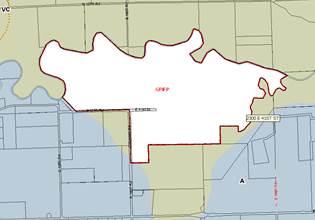
To the west: A (County-Agricultural) and V-C (County-Valley Channel) Districts and the F-F (Floodway Fringe) Overlay District; Agricultural uses and scattered rural residences. To the south: A (County-Agricultural) and V-C (County-Valley Channel) Districts and the F-F (Floodway Fringe) and F-W (Floodway) Overlay Districts; Agricultural uses and scattered rural residences. To the east: A (County-Agricultural) and the F-F (Floodway Fringe) and F-W (Floodway) Overlay Districts; Agricultural uses, woodland, and scattered rural residences. To the north: V-C (County-Valley Channel) and and the F-F (Floodway Fringe) and F-W (Floodway) Overlay Districts; Wakarusa River and agricultural uses. (Figure 1) |
|
|
|
|
|
|||
|
Figure 1a. Zoning in area. Zoning Districts outside the City limits are highlighted. (Subject property outlined) |
Figure 1b. Land use in area. (Subject property is outlined.) |
|||
Summary of Special Use
The proposed wastewater treatment plant will serve the community and accommodate future growth. The treatment plant meets the definition of a Major Utility in Section 20-1764 of the Development Code:
MAJOR UTILITIES: Services and utilities that have substantial impacts. Such uses may be permitted when the public interest supersedes the usual limitations placed on land use and transcends the usual restraints of the district for reasons of necessary location and community-wide interest. Typical uses include: water and wastewater treatment facilities, major water storage facilities, airports, and power generation plants.
This wastewater plant was recommended in the City Wastewater Masterplan and the project has been underway since 2007 with the annexation and rezoning of the property. A preliminary plat and SUP had been approved in 2007; however, the slowdown in the economy in 2008 put the project on hold and the SUP and plat approvals expired. The facility is proposed in the same location as in the 2007 SUP.
The plant will be located on Lot 1, Wakarusa Wastewater Treatment Plant Addition and will utilize approximately 15 acres of the 530 acres available on the lot. The remainder of the lot will remain in agricultural production. The treatment plant will include an administrative building with meeting rooms. A conference room is being considered and is being shown on the plans as an alternate bid. The presence of floodplain on the property will require local Floodplain Development Permits for the placement of fill as well as the construction of the facility.
|
SITE SUMMARY: |
||
|
|
Existing |
Proposed |
|
Property Area: |
531.29 acres |
531.29 acres |
|
Total Impervious Area: |
72,530 sq ft (1.67 acres) |
507,256 sq ft (11.64 acres) |
|
Total Pervious Area: |
529.62 acres |
519.65 acres |
|
|
|
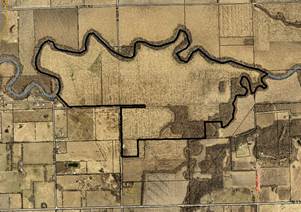
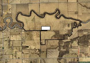
Figure 2. General location of proposed plant (highlighted) and mitigation channel on subject property. |
Site Plan Review
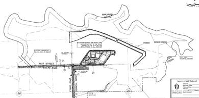
The subject property contains approximately 531 acres and is located north and east of the intersection of O’Connell Road (extended E 1600 Road) and 41st Street (extended N 1175 Road). It is bounded on the north by the Wakarusa River and on the east by Coal Creek. The proposal is to construct a wastewater treatment plant on approximately 15 acres, in the general location shown in Figure 2.
A mitigation channel and outfall is designed to the north of the facility for stormwater management. The project will be developed in phases and the additional area will allow the size of the plant to be increased while still providing an effective buffer.
A wide buffer of open space is planned for periphery of the site. The width of the riparian buffer to be protected along the Wakarusa River and Coal Creek is noted on the plan as 200 ft and 100 ft respectively. A 75’ bufferyard is required on all sides of a GPI District per Section 20-1307(2) of the Development Code. The 75 ft bufferyard on the periphery of the site that is not with the riparian corridors should be shown on the plan. Alternative Compliance has been approved for the peripheral bufferyard based on the existing vegetation and the agricultural use in this location. The bufferyard requirement along 41st Street interior to the site has been administratively waived due to the fact that the subject property is on both sides of the street.
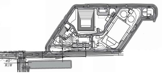
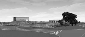
The treatment plant will include an administrative building with offices and meeting rooms. A solar array is planned south of the facility to provide electricity for portions of the facility. Most of the features associated with the treatment plant will be located at or below grade. The structures that will be above grade are highlighted and numbered in Figure 3. These are the administration building (1), headworks (2), vehicle storage and maintenance (3), chemical storage (4), electrical switchgear (5), solids thickening (6), sludge pumping station (7), and ultra violet disinfection (8).
|
8 7 6 5 Solar array location 4 3 2 1 |
||||||||||||||||||
|
Figure 3. Above grade features highlighted. The administration building and headworks are visible from right-of-way. |
|
|
|
|
Figure 4a. View from right-of-way at intersection of O’Connell Road (E 1600 Rd extended) and 41st Street (N 1175 extended). The headworks is the structure on the left and the administration building on the right. |
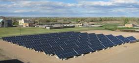
Figure 4b. Example of solar panel array to be located south of the facility, across 41st Street. |
Review and Decision-Making Criteria (20-1306(i))
1. WHETHER THE PROPOSED USE COMPLIES WITH ALL APPLICABLE PROVISIONS OF THIS DEVELOPMENT CODE
Applicant’s Response:
“Yes. The proposed use complies with all applicable provisions of the Development Code.”
The proposed use, a Major Utility, is an allowed use in the GPI (General Public and Institutional Use) District subject to Special Use Permit (SUP) approval. The property is completely encumbered with the Regulatory Floodplain; therefore, a Floodplain Development Permit is required per Section 20-1203 and must be approved prior to the release of building permits. The City selected a site of over 500 acres to allow adequate open space to buffer the use from neighboring properties and to allow room for any plant expansion which may be necessary to accommodate future growth in the city’s population. Section 20-1307(c)(2) requires an Institutional Development Plan for sites greater than 10 acres to be approved by a Special Use Permit, which provides for a public hearing for the item. The Institutional Development Plan serves as the master plan for the project, so future phases are shown on the plan. The future improvements shown on the IDP will require approval through the administrative site plan process.
ACCESS
The Code recommends that uses in the GPI District be located along collector or arterial streets. This is appropriate for most of the permitted uses in the GPI District, such as recreation centers, schools, and public buildings, but is not appropriate for this particular use. A wastewater treatment plant will have less public traffic than other uses permitted in the GPI District so access to a collector or arterial road is not necessary. In addition, the large area being provided as a buffer requires a relatively isolated location. Given these factors, the location of the facility on a local street is appropriate.
E 1600 and N 1175 Roads were previously designated as Minimum Maintenance Roads. Per the County Access Management Standards, Minimum Maintenance Roads typically provide access for low speed agricultural vehicles where a minimum maintenance level of service will not have a significant impact on local traffic circulation. As these roads will provide the primary access to the site, they are no longer suited for minimal maintenance. The Board of County Commissioners rescinded the Minimum Maintenance designation on January 22, 2014 with adoption of Resolution No. 14-03.
Improvements to these roads are necessary to provide suitable access for the traffic that will be generated by the construction activities and the wastewater plant. E 1600 Road will be improved from the intersection of N 1175 Road and E 1600 Road south to 1100 Road. N 1175 Road will be improved from the intersection of N 1175 Road and E 1600 Road west to E 1500 Road. The improvements include fill, grading, and surfacing work. Drainage ditches and culverts will also be constructed as a part of the project.
PARKING
Per Section 20-902 of the Development Code, a minimum of one off-street parking space is required for each 1.5 employees with the Major Utility use. The facility will employee 25 employees; therefore, 17 parking spaces are required. The plan notes that 20 parking spaces with 1 ADA accessible space would be provided. 3 stalls are provided for the fleet vehicles.
As the IDP serves as the master plan, an alternate parking summary is included on the plan. If the administration building contains an accessory conference room, parking for that use would be required at a rate of 1 stall per 4 seats. The conference room would have 145 seats; therefore 37 stalls would be required. A total of 57 parking spaces (including 3 ADA) and 6 bicycle spaces would be required and are provided on the plan. The plan notes that the size of the parking lot will vary depending on whether or not the accessory conference room is included.
The parking provided on the plan complies with the Development Code.
LIGHTING
The plan notes that full cut-off fixtures will be used but the lighting locations will be determined when the utilities have been routed. A photometric plan will need to be submitted to the Planning Office for review and approval prior to the release of the SUP plan for building permits.
SETBACKS/BUFFERYARDS
The following setbacks are required in the GPI District:
· Where abutting street right-of-way: 40 ft
· Where abutting residential district: 40 ft
· Where abutting non-residential district: 15 ft
The property was an island annexation and is surrounded by property in the unincorporated portion of the County that is zoned for agricultural uses. This area is not located within the boundaries of any adopted long range plan; therefore, future recommended land uses have not been identified. The administration building is located approximately 120 ft from the right-of-way for 41st Street and the remaining area being developed at this time is located within the interior of the site and is not within the required setbacks.
Section 20-1307(c)(2) requires a Type 3 Bufferyard along the perimeter of the property. Alternative compliance has been approved from this requirement due to the size of the property, the agricultural use of the property, and the natural vegetation occurring on the site. A bufferyard is not required along the right-of-way for 41st Street within the property as the lot is located on both sides of this dead-end street. This waiver should be noted on the plan.
SIDEWALKS
Per Section 20-1307(c)(2), sidewalks are required on all street frontages as part of the first phase of a project in the GPI District. An administrative waiver has been granted from this requirement based on the fact that the property is surrounded by land in the unincorporated portion of the County and no connecting sidewalks are available. When the surrounding properties are developed to urban standards, sidewalks shall be provided along the street right-of-way. This is noted on the plan.
LANDSCAPING AND SCREENING
The required street trees will be clustered near the intersection of 41st Street and O’Connell Drive/E 1600 Road. Native grasses and plants are being used as much as possible for the landscaping materials.
Interior Parking Lot
The Code requires 40 sq ft of landscape area for each parking space and 1 tree and 3 shrubs per 10 parking spaces. The plan shows the layout for the alternate proposal, with the conference room, as it would be the most intensive and notes the required landscaping for both the alternate proposal (with conference room) and the base proposal (without conference room). The plan notes that if the base proposal is chosen the landscaping provided on the plan would be reduced to that which is required. The amount of landscaping provided is compliant with Code; however, the City horticulture manager had some recommendations for revised species and locations. The plan should be revised to incorporate her recommendations.
Perimeter Parking Lot
Per Section 20-1004 of the Development Code, parking lots shall be screened from view of street rights-of-way with a minimum of 1 tree per 25 ft of parking lot frontage and a masonry wall, fence, or continuous hedge. A portion of the parking lot fronts on to the 41st Street right-of-way. As this right-of-way is located within the interior of the site and functions more as a drive than a street; perimeter parking lot landscaping is required but may not provide a public purpose. In accordance with Section 20-1004, the Planning Director waived the perimeter parking lot landscaping requirement following a determination that the overall spirit and intent of this Development Code is not undermined by granting the waiver. This should be noted on the plan.
Staff Finding – The proposed use, as conditioned, is compliant with the provisions of the Development Code with the following administrative approvals: a) waiver from the Type 3 Bufferyard requirement along 41st Street interior to the site, b) waiver from the requirement to install sidewalks on both sides of the adjacent streets until such time as the surrounding properties are developed to urban standards, c)waiver from the requirement to install perimeter parking lot landscaping along 41st Street and d) approval of Alternative Compliance for the Type 3 Bufferyard landscaping along the perimeter of the property.
2. WHETHER THE PROPOSED USE IS COMPATIBLE WITH ADJACENT USES IN TERMS OF SCALE, SITE DESIGN, AND OPERATING CHARACTERISTICS, INCLUDING HOURS OF OPERATION, TRAFFIC GENERATION, LIGHTING, NOISE, ODOR, DUST AND OTHER EXTERNAL IMPACTS
Applicant’s Response:
“Yes. The proposed facility is compatible with adjacent uses, which are primarily agricultural. The design of the Wakarusa Wastewater Treatment Plant will allow for significant buffers surrounding the operating facility. Therefore, impacts to adjacent owners will be minimal.”
The selected property is located in Service Area 4 of the Urban Growth Area. It is bounded on the north and east by the Wakarusa River and Coal Creek. Currently the uses surrounding the property are agricultural. The proposed use is not one that would typically be compatible with residential development. The selection of an isolated site and the inclusion of adequate land area to allow on-site buffering of the use will allow it to be compatible with the adjacent uses currently in place and also with development in the future.
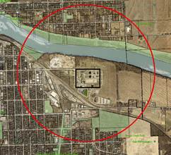
The use is not expected to generate significant traffic. The lighting will be full cut-off fixtures and a photometric plan will be provided to insure the lighting is confined to the site. There is occasionally some odor associated with this use; but the existing residences in the area are located far enough from the facility that it should not affect them. Figure 5 shows the distance to the nearest residence from the proposed SUP and shows the land uses that are within that distance from the existing wastewater treatment plant. The proposed use should have no impact on the existing residences, given their separation from the facility.
|
~3,700’ ~3,000’ ~2,680’ |
|
||||||
|
Figure 5a. Distances to nearest residences. |
Figure 5b. Area within 2600 ft of the boundaries of the existing wastewater treatment plant. |

Staff Finding – The proposed use, as planned, is compatible with adjacent land uses.
3. WHETHER THE PROPOSED USE WILL CAUSE SUBSTANTIAL DIMINUTION IN VALUE OF OTHER PROPERTY IN THE NEIGHBORHOOD IN WHICH IT IS TO BE LOCATED
Applicant’s Response:
“No. In fact property values are likely to rise due to the potential development that may occur on these properties after completion of the wastewater treatment plant.”
The surrounding areas are agricultural lands, with scattered rural residences. The large size of the site and its relative isolation should minimize its impact on surrounding properties. The roads used for access to the site will be improved to standards that will accommodate the anticipated traffic. The plant may provide additional sewer capacity so that additional development may occur to the south of Lawrence; however, urban development would be tied to connection to City services which could occur only following annexation into the city.
Staff Finding – The location of the plant should provide adequate buffering to minimize any negative impacts on the neighborhood. No diminution of property values is anticipated.
4. WHETHER PUBLIC SAFETY, TRANSPORTATION AND UTLITY FACILITIES AND SERVICES WILL BE AVAILABLE TO SERVE THE SUBJECT PROPERTY WHILE MAINTAINING SUFFICIENT LEVELS OF SERVICE FOR EXISTING DEVELOPMENT
This area is not contiguous to other City properties so City utilities do not currently exist in this area. The subject property is being developed to provide utility services for future development and to increase capacity for the City of Lawrence. The extension of water lines to the plant will be determined during the design phase of the project. Sanitary sewer mains are being planned to direct flow to the facility.
Staff Finding – The subject property will provide wastewater utility facilities for the surrounding area when it is incorporated and the City of Lawrence. City water will be available to the surrounding areas as they annex, as water lines will be extended to serve the facility. Adequate services will be available to serve the subject property and services will become available to surrounding development. There should be no impact on the current utility services in the area.
5. WHETHER ADEQUATE ASSURANCES OF CONTINUING MAINTENANCE HAVE BEEN PROVIDED
Staff Finding – This is a phased project and site plans will be required for each phase. The site plan will function as the enforcement document to assure that maintenance and use of the property is consistent with the approval.
6. WHETHER THE USE WILL CAUSE SIGNIFICANT ADVERSE IMPACTS ON THE NATURAL ENVIRONMENT
Applicant’s Response:
“No. KDHE will regulate the construction and effluent of the facility to ensure that the surrounding environment is not adversely impacted.”
The proposed facility will have positive environmental impacts and will improve the quality of effluent water due to year-round nutrient removal. The proposed Wakarusa Wastewater Treatment Plant (WWTP) is located within the Wakarusa and Coal Creek floodplain. To protect the WWTP from future flooding, the site is being raised to approximately the 500-year flood level. A flood mitigation channel is being designed and constructed to meet the City’s no-rise requirement. A NPDES (National Pollution Discharge Elimination System) Permit has been obtained from the Kansas Department of Health and Environment (KDHE) for the Wakarusa WWTP. There are a number of other regulatory/permitting agencies that have been involved with this project. Approvals have been or will be obtained from the following permitting agencies: KDHE, USACE (US Army Corps of Engineers), KDWR (Kansas Division of Water Resources), KBS (Kansas Biological Survey), KSHS (Kansas Historical Society), KDWPT (Kansas Department of Wildlife, Parks and Tourism, and the City and County Floodplain Administrators.
Staff Finding – The proposed use, with the protection measures required by Federal, State and Local governments, should not cause significant adverse impacts on the natural environment.
7. WHETHER IT IS APPROPRIATE TO PLACE A TIME LIMIT ON THE PERIOD OF TIME THE PROPOSED USE IS TO BE ALLOWED BY SPECIAL USE PERMIT AND, IF SO WHAT THAT TIME PERIOD SHOULD BE.
Time limits are established on Special Use Permits to permit a periodic review to determine if the use remains compliant with the area or if a rezoning would be appropriate. A wastewater treatment plan is part of necessary infrastructure whose life span will be determined by demand and operational characteristics. It would not be appropriate to place a time limit on this use.
Staff Finding – The proposed use is a major utility which is being planned to serve future development in the area and within the City of Lawrence. Because of the nature and magnitude of the project it would not be appropriate to place a time limit on the proposed use.
Conclusion
The proposed wastewater treatment plant will benefit the community by increasing the sanitary sewer capacity which will accommodate growth within the City. The use, as planned, is compatible with this location. Staff recommends approval of the Special Use Permit as conditioned.