|
PLANNING COMMISSION REPORT Regular Agenda -Public Hearing Item
|
|
PRELIMINARY DEVELOPMENT PLAN FOR THE LINKS; 251 QUEENS RD (MKM) |
PDP-14-00171: Consider a Preliminary Development Plan for The Links at Lawrence, a 900 unit apartment complex, on approximately 78 acres located at 251 Queens Rd. Submitted by Blew & Associates PA, for Links at Lawrence, property owner of record.
|
STAFF RECOMMENDATION ON PRELIMINARY DEVELOPMENT PLAN: Planning Staff recommends approval of The Links at Lawrence Preliminary Development Plan based upon the findings of fact presented in the body of the staff report and subject to the following conditions:
1. Agreements not to protest the formation of a benefit district must be executed by the applicant and provided to the Planning Office before recording of the Final Development Plan for the following: a. Street and sidewalk improvements for Queens Road. b. Street and sidewalk improvements for George Williams Way. c. Geometric intersection improvements for Queens Road and Wakarusa Drive. d. Intersection improvements, geometric and signalization, for Queens Road and W 6th Street. e. Intersection improvements, geometric and signalization, for George Williams Way and Rock Chalk Drive.
2. Provision of a revised Preliminary Development Plan with the following changes: a. Provide a continuous evergreen hedge, or 6 ft solid fence or wall along the south side of the parking/drive area in the Southeast Quadrant of the development adjacent to the proposed Kellyn Addition. b. Provide a 12 ft Pedestrian Access Easement for the shared use path within the Utility Easement for the Sanitary Sewer Interceptor Line and add the following note: “A 12’ shared use path will be constructed by the property owner within the pedestrian easement to City standards, at the time of this development. The path will terminate 50’ south of the north property line with a mini cul-de-sac. When a connecting trail has been constructed on the property to the north, the developer of this project will construct the remaining 12’ wide connecting piece of the shared use path.” c. Make minor changes to utilities shown on the plan per City Utilities Engineer’s comments. d. Make minor changes to the plan per the City Fire Code Official’s comments. e. Add the following note: “Prior to any construction activity the perimeter of the protected wooded areas adjacent to the construction activity will be fenced at the drip line and signage will be erected that notes that any construction activity, grading, trenching or storage is prohibited within the fenced area. f. Note the number of van accessible ADA parking spaces provided in the parking data for each phase. g. Revise the Parking Summary to note the bicycle parking requirement as 1 space per 4 auto spaces provided, provide the required additional bicycle parking spaces, and show the location of the bicycle parking on the plan. h. Relocate bufferyard landscaping along the south property line north of the 25 ft utility easement. If necessary widen the bufferyard by relocating the buildings to the north to provide adequate landscaping area. i. Revise plan based on minor technical issues. Staff will provide the applicant with a list. 3. Stormwater Engineer is currently reviewing the revised plans and will provide comments that may result in revisions to the plan, including possibly requiring a detention pond on the southwest corner.
|
|
Reason for Request: |
The changes proposed from the formerly approved Preliminary Development Plan meet the definition of a Major Change and require the rehearing and reapproval of a Preliminary Development Plan (Section 20-1304(d)(11)(v).
|
||
|
KEY POINTS · Environmentally sensitive lands, including a stream corridor and stands of mature trees, are located on the subject property. · A modification had previously been approved from the height requirement. No modification is being requested with this plan. · Per Section 20-701(f)(3) density calculations in the PD Overlay District are weighted based on the number of bedrooms proposed in a dwelling unit. · The changes proposed with this development plan which are considered Major Changes are the relocation of the recreation common open space, and an increase of more than 5% of the total ground area covered by buildings (13.8% increase). |
|||
|
FACTORS TO CONSIDER · Conformance with the purpose of Planned Developments (Section 20-701, Development Code). · Compliance with Development Code. · Conformance with Horizon 2020. · Conformance with Subdivision Regulations.
|
|||
|
ASSOCIATED CASES ANNEXATION · The City Commission approved annexation request (A-11-07-07) at their February 26, 2008 meeting. The annexation became effective with adoption and publication of Ordinance 8825. REZONING · The City Commission approved rezoning requests [Z-11-28A-07 and Z-11-28B-07] to the RM12 District and –PD Overlay Districts at their February 26, 2008 meeting. The RM12 rezoning was conditioned to permit a maximum residential density of 6 dwelling units per acre. These rezonings became effective with adoption and publication of Ordinance Nos. 8226 and 8227.
DEVELOPMENT · The City Commission approved a Preliminary Development Plan [PDP-11-06-07] for The Links at Lawrence, a Planned Residential Development containing 40 multi-dwelling buildings with 12 dwelling units per building for a total of 480 dwelling units, on February 27, 2008. · A Final Plat (PF-08-05-09) and Final Development Plan (FDP-08-07-09) were submitted in August of 2009. · A revised Preliminary Development Plan (PDP-12-00283) was submitted in 2012 to utilize the weighted density calculations afforded in the Planned Development Overlay District. This plan was approved by the City Commission on February 19, 2013. · The subject revised Preliminary Development Plan was submitted to allow for a reconfiguration of the building/parking layout, relocation of the recreational common open space and an increase in density in terms of both dwelling units per acre and total number of units. The relocation of the recreation open space and increases by more than 5% the ground area covered by buildings are considered ‘Major Changes’ by Code and require the rehearing and reapproval of a Preliminary Development Plan.
OTHER ACTION REQUIRED · City Commission approval of Preliminary Development Plan. · Submittal and administrative approval of Final Development Plan. · Recording of Final Development Plan with the Douglas County Register of Deeds. · Submittal and administrative approval of Final Plat. · City Commission acceptance of dedications shown on the Final Plat. · Public Improvement Plans submitted to City Public Works and Utilities Departments. The plans must be approved and the means of ensuring completion of public improvements accepted prior to recording the Final Plat. · Recording of the Final Plat with the Douglas County Register of Deeds. · Building permits must be obtained prior to construction of structures.
|
|||
|
PUBLIC COMMENT · Jack Graham, adjacent property owner to the north, visited the Planning Office to discuss the development and provided the following comments: --A fence should be built along the north property line, this could be a wire fence built within the trees, in areas where the tree cover is thick. --The trail should not be constructed to the north property line until a connecting trail is constructed on the property to the north. --Lighting should be evaluated to insure no glare or trespass on his property.
|
|||
|
GENERAL INFORMATION |
|
|
|
|
Current Zoning and Land Use:
|
RM12-PD (Multi-Dwelling Residential with Planned Development Overlay) District; woodland and agricultural uses. (Planned residential development has received preliminary approval.)
|
|
|
|
Surrounding Zoning and Land Use:
|
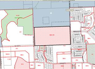
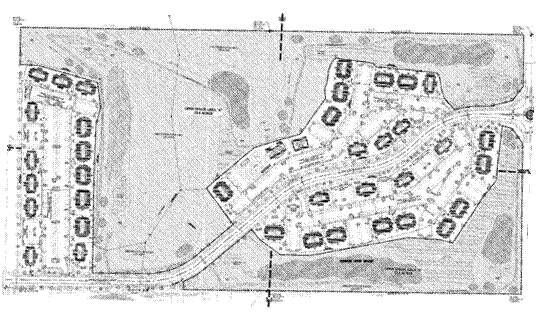
To the west: GPI (General Public and Institutional Use) District; Rock Chalk Park KU/Regional Sports Facility and City Recreation Center, General Entertainment and Spectator Sports and Participant Sports & Recreation (Indoor and Outdoor). To the north: Property outside the city limits which is zoned A (County-Agricultural); rural residences, woodland, and agricultural uses. To the east: RS7 (Single-dwelling Residential) District, single-dwelling residences. PRD-Westwood Hills (Westwood Hills Planned Residential Development); undeveloped. To the south: RM12D (Multi-dwelling Residential), RS7 (Single-dwelling Residential), OS (Open Space) Districts; platted subdivisions which have not yet been developed. The OS area has been designated as a city park. (Figure 1.) |
|
|
|
|
|
|
|
|
Area |
|
|
Gross Area |
81.31 acres previous plan 79.46 acres (due to dedication of right-of-way for George Williams Way) |
|
Right-of-Way |
6.74 acres (due to dedication of right-of-way for George Williams Way) |
|
Net Area |
72.72 acres |
|
Lot 1, Block One* |
29.57 acres |
|
Lot 2, Block One (labeled as Lot 4)* |
20.80 |
|
Lot 1, Block Two (labeled as Lot 2)* |
22.06 acres |
|
Lot 1, Block Three (labeled as Lot 3)* |
.33 acres (14,374 sq ft)
|
|
*These lots should be re-labeled on the plat sheet and throughout the PDP to reflect the lot and block numbers referenced above. |
|
|
SITE SUMMARY |
|||
|
|
Existing |
Proposed |
Change |
|
Land Use: |
Woodland and Agriculture |
Multi-Dwelling Residential, accessory parking, passive and active recreation |
Change in use (No change from previously approved use) |
|
Land Area: |
79.46 acres |
72.72 acres |
-6.74 acres (right-of-way) |
|
Building Area: |
0 sq ft |
278,605 sq ft (244,807 sq ft previous plan) |
+278,605 sq ft (+33,798 sq ft from previous plan |
|
Pavement Area: |
0 sq ft |
633,128 sq ft |
+633,128 sq ft |
|
Impervious Area: |
0 sq ft |
911,733 sq ft (28.8%) |
+ 911,733 sq ft |
|
Pervious Area: |
3,167,571 sq ft |
2,255,838 sq ft (71.2%) |
- ..911,733 sq ft |
|
|
|
|
Figure 1a. Zoning in the area. |
Figure 1b. Land use in the area. The green highlighted area is City parkland. |
|
Parking Summary |
|||
|
Use |
Req. per Sec 20-902 |
Parking Required |
Parking Provided |
|
Multi-Dwelling Residential
|
1 vehicle space / bedroom + 1/10 units for visitors |
Phase 1: 1,038 bedroom + 650 units (65 spaces) =1,103 spaces
Phase 2: 430 bedrooms plus 258 units (26 spaces) = 456 spaces |
1,103
456 |
|
TOTAL |
|
1,559 spaces |
1,559 spaces |
|
ADA Accessible Spaces |
Phase 1: Parking areas with over 1,000 spaces: 20 spaces plus 1 for every 100 over 1000; 1 of every 8 spaces must be van accessible
Phase 2: Parking areas with between 401 and 500 parking spaces: 9 spaces with 2 being van accessible.
|
Phase 1: 22 ADA spaces 3 van accessible
Phase 2: 9 spaces 2 van accessible |
Phase 1: 23 van accessible*
Phase 2: 11 van accessible* |
|
Bicycle Parking |
1 per every 4 vehicle spaces |
Phase 1: 1103 spaces—276 spaces
Phase 2: 456 spaces—114 spaces |
Phase 1—161**
Phase 2—65**
|
* The parking summary on the plan should be revised to note how many van accessible ADA parking spaces are provided to insure compliance with Code.
**The bicycle requirement should be noted on the plan as 1 per 4 auto spaces shown. Additional bicycle parking should be provided and the location of the bicycle parking should be shown on the plan.
STAFF ANALYSIS
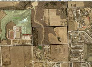
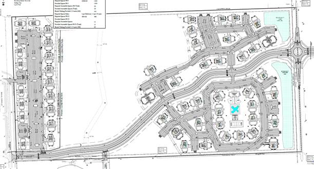
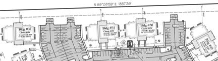
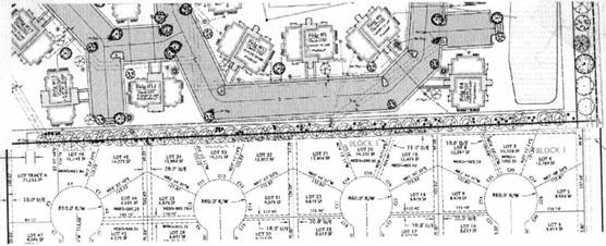
The property contains approximately 72 acres and is located approximately ½ mile north of W 6th Street between Queens Road and George Williams Way. The development will consist of 900 dwelling units and recreational amenities which will be developed in 2 phases. The apartments on the east portion of the property and Rock Chalk Drive will be developed as Phase 1, and the apartments lining George Williams Way will be developed as Phase 2.
Residential development is adjacent to the property on the east and is planned for the property to the south. The property to the west was recently rezoned to the GPI (General Public and Institutional Use) District and developed as a regional sports/athletic center. The property to the north is agricultural/rural land outside the city limits. This area is not included in a current long range plan, but the Northwest Area Plan recommended low density residential uses for this area. Based on the long range plan’s recommendation, staff is assuming residential development will also occur to the north of the subject property.
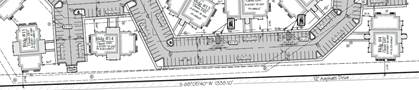
Access to the development will be provided from Rock Chalk Drive through the property as well as one access point on George Williams Way. The owners of the subject property dedicated additional right-of-way for George Williams Way prior to platting to accommodate street improvements necessary for the sports center.
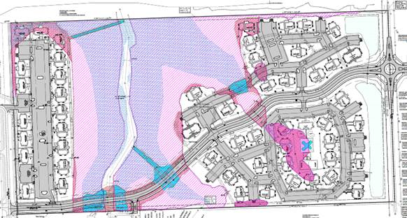
When development was originally proposed on this property in 2007, the Development Code required all residential developments with sensitive lands to develop either as a Cluster Development or as a Planned Development. The property was rezoned to a base district with a planned overlay district and development plans were submitted. The Code required that a minimum of 20% of the site be set aside as common open space and that 50% of the area set-aside be developed as Recreational Open Space. As the proposal was to develop apartments with a nine-hole golf course, more than 20% of the site was proposed as common open space. Approximately 46 acres or 63% of the site was proposed to be maintained as common open space with the original submittal; however, some of the common open space was to be developed with golf course and lakes. The 2012 revised plan proposed approximately 44 acres of common open space (60%) and relocated some of the golf course from the wooded areas and removed the lakes. The golf course was removed from the project with the current plan which proposes approximately 47.4 acres of common open space with 23.6 acres being developed for recreational uses, leaving 23.8 acres as natural open space. The recreational open space includes a tennis court, basketball court, putting green, swimming pool, and clubhouse. The environmentally sensitive areas are shown on Sheet C3-5 of the plan set. Per Code, only the stream corridor and stands of mature trees are recognized as environmentally sensitive lands but the developer included information on the steep slopes as well.
· Total site area: 79.45 acres, net area: 72.72 acres
· Stands of Mature Trees pre-development: 31.0 acres, 39% of total site (42.6% of net area)
· Stands of Mature Trees post-development: 23.8 acres, 30% of total site (32.7% of net area)
· Steep Slopes pre-development: 17.92 acres, 22.5% of total site (24.6% of net area)
· Steep Slopes post-development: 16.33 acres, 20.6% of total site (22.5% of net area)
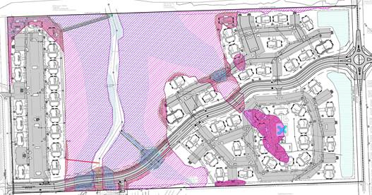
With the removal of the golf course from the wooded areas, the amount of contiguous wooded area that is preserved was increased. See Figure 2.
|
|
|
Figure 2a. Sensitive Area Site Plan. Stands of Mature Trees shown in red, steep slopes above 15% in blue. |
|
|
|
Figure 2b. Protected area and recreational open space with 2012 approved plan. This plan did not show the City’s sanitary sewer interceptor line which crosses the site from north to south. |
Other changes being proposed with this Preliminary Development Plan include an increase of more than 5% in the building coverage on the site, and an increase in density from 4.65 dwelling units per acre to 6 dwelling units per acre. The relocated common open space and the increase in building coverage are considered major changes; therefore, a revised Preliminary Development Plan has been submitted for rehearing and consideration.
The following table compares the previously approved and current development plans:
|
|
2012 Approved PDP |
Proposed PDP |
Change |
|
Site Area |
72.76 acres |
72.72 |
-- |
|
Common Open Space (% of total) |
43.88 acres (60.3%) |
47.4 acres (65.1%) |
+ 3.52 acres |
|
Protected Sensitive Lands(% of total) |
14.62 acres 20% of total site |
23.8 acres 32.7% of total site |
+ 9.18 acres |
|
Number of buildings |
37 |
53 |
+16 |
|
Number of dwellings |
630 |
900 |
+ 270 |
|
Number of bedrooms |
1050 |
1468 |
+ 418 |
|
Density (weighted) |
4.65 du/acre |
6 du/acre |
+1.35 du/acre |
|
Parking Provided |
1164 spaces |
1559 spaces |
+395 spaces |
|
Building Area |
244,807 sq ft |
278,605 sq ft |
+ 33,798 sq ft |
|
Impervious Surface |
468,269 sq ft (14.8%) |
1,104,307 sq ft (34.8%) |
+ 636,038 sq ft |
|
Building Height |
41.5 Club House 39 ft Apartment (max) |
25.9 ft Club House 35 ft Apartments (max) |
No modification required |
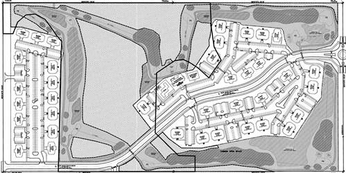
Figure 3 compares the development pattern in the previously approved PDP and that being proposed with the current PDP.
|
|
|
Figure 3a. Previously approved PDPs had similar layouts. The 2012 PDP reduced the golf course area and expanded the building area. (Approximate boundaries of 2007 Development is outlined in red for comparison.) |

|
|
|
Figure 3b. The changes with the current plan include the relocation of the recreational common open space and a reconfiguration of the building/parking area layout. (2012 approximate layout overlaid in red.) |

The proposed Preliminary Development Plan for The Links at Lawrence has been evaluated based upon findings of fact and conclusions per Section 20-1304(d)(9) of the Development Code for the City of Lawrence, requiring consideration of the following nine items:
1) The Preliminary Development Plan’s consistency with the Comprehensive Plan of the City.
The subject property is within the Baldwin Creek Drainage Basin, an area in which Horizon 2020 recommends development not be permitted until plans to extend sanitary sewer service to the entire drainage basin have been developed. The West Baldwin Creek Sanitary Sewer Interceptor from pump station PS45 located along the north edge of the Oregon Trail Addition north and east through the subject property to the pump station PS48 has been completed.
The Comprehensive Plan recommends that new large-scale, low-density, single-family residential development be located to the west of the city, with the area east of the South Lawrence Trafficway being developed prior to the area to the west. (page 5-4) The proposed development is a large-scale, low-density residential development which is proposing multi-dwelling rather than single-dwelling residences.
Policy 5.1 of the plan recommends that natural environmental features within residential areas be preserved and protected. (page 5-19) The Preliminary Development Plan clusters the dwelling units, parking areas, and recreational open space leaving approximately 23.8 acres as natural open space which insures the protection of natural features and sensitive lands. With previously approved development plans, a portion of the common open space was to be used for a nine-hole golf course, but 20% of the site was designated as natural open space. With the current plan, the golf course has been removed from the environmentally sensitive area and 23.8 acres of the sensitive area is to be protected. (76.8% of the environmentally sensitive area, 32.7% of the total site area). This exceeds the 20% required by Code and is an increase from the 17.09 acres provided with the 2012 plan.
The Comprehensive Plan recommends that Development Proposals be reviewed for compatibility with existing land uses, including any neighborhood plan. (Policy 4.1, page 5-17) The property lies within the boundary of The Northwest plan (1997). The Northwest Plan recommends that residential uses vary from W 6th Street to the north from higher density near W 6th Street to lower density northward. The Northwest plan recommends low-density, which the development proposal meets; but also recommends single-family residences. The typical land use arrangement at the time the Northwest plan was adopted was for single-family residences to be lower density and multi-family residential developments to be higher density. With the adoption of the 2006 Development Code new single-dwelling zoning districts were created which could be developed at ‘medium-density’. Under the Development Code, the level of density does not dictate the housing type as it did when the Northwest Plan was adopted.
While the Northwest Area Plan was adopted in 1997, it is used as a guiding document for development in the area with consideration being given to changes in the Code. The Northwest Area Plan recommended low density development as a means to protect the environmentally sensitive features: stream corridor, steep slopes, woods, in the area. Since the adoption of the Northwest Area Plan in 1997, additional protection measures have been adopted by the City. Section 20-1101 of the Development Code contains standards for the protection of sensitive lands on residential properties. The proposed use, an apartment complex, utilizes a cluster form of housing which concentrates the street and utility extensions rather than the overall extension that would be required with standard, single-dwelling, low density housing.
Chapter 16 of the Comprehensive Plan - Environment, recommends the following (staff discussion follows each recommendation in italics):
· “Development should maintain the natural benefits of existing topography. Development on steep slopes (above 15%) should be done in a manner that encourages the use of the existing topography with minimal grading to minimize adverse effects.” (Policy 2.1, page 16-12)
Steep slopes were included in the sensitive area site plan, although the Development Code does not require their protection as environmentally sensitive lands. The improvements being proposed to the site are located outside of this area with the exception of a portion of Rock Chalk Drive and an access drive on the southern reach of the steep slopes. (Figure 3)
· “Encourage environmentally sensitive site design practices which minimize the unnecessary physical and visual impacts upon the surrounding landscape caused by removal of woodlands.” (Policy 2.2(a)(2), page 16-12)
Removing the proposed golf course from the wooded area allows a larger, more contiguous wooded area to be protected. A 50 ft to 100 ft clearing was created in a utility easement with the installation of the Baldwin Creek Interceptor Line. A 12’ shared use path will be constructed by the property owner within the pedestrian easement to City standards, at the time of this development. The path will terminate 50’ south of the north property line with a mini cul-de-sac. When a connecting trail has been constructed on the property to the north, the developer of this project will construct the remaining 12’ wide connecting piece of the shared use path.
|
|
|
Figure 4. Steep slopes (>15%) shown in blue dots. Stands of mature trees shown in red hatchmarks. Stands of mature trees that will be removed are shown in bright pink and steepslopes/stands of mature trees that will be disturbed are marked in bright blue. |
Staff Finding – The proposed development complies with the general land use provisions found in Horizon 2020 and the Northwest plan. A low-density multi-dwelling development is unique and is being proposed here to allow for the development with the extraordinary protection of open space and natural features. The development does not conform strictly with the wording of the Northwest plan, but does comply with the intent of providing low-density residential development further from W 6th Street and with Horizon 2020’s recommendation of low-density residential development and the protection of natural features.
2) Preliminary Development Plan’s consistency with the Planned Development Standards of Section 20-701 including the statement of purpose.
The purpose statement includes the following (staff comments follow in italics):
a) Ensure development that is consistent with the comprehensive plan.
As discussed previously, the development is consistent with the comprehensive plan and the adopted plan for the area.
b) Ensure that development can be conveniently, efficiently and economically served by existing and planned utilities and services.
Waterlines are located within the area and the Baldwin Creek Interceptor Sewer Line has been installed through the property. The development can be conveniently served by existing utilities and services.
c) Allow design flexibility which results in greater public benefits than could be achieved using conventional zoning district regulations.
This area could develop as a conventional RM12 District, however when rezoned in 2006 the Development Code required that properties containing substantial amounts of environmentally sensitive lands, as defined by Code, be developed as a Planned Development. The Development Code has since been revised to remove this requirement and allow properties with environmentally sensitive lands to develop with base zoning through the site planning process. Design flexibility is provided through the planned development process through modifications to the standards in the base district such as a smaller lot size, increased density, reduced setbacks, increased height, and a change in parking requirements. These modifications allow the development to be tailored to the particular use and the site specific characteristics.
d) Preserve environmental and historic resources.
There are no known historical resources in this area. The environmental resources in the area are the stands of mature trees and the stream corridor. The plan concentrates development on the more level areas which allows for the protection of the stream corridor and much of the wooded area.
e) Promote attractive and functional residential, nonresidential, and mixed-use developments that are compatible with the character of the surrounding area.
65.1% of the total land area is being set aside as common open space. The buildings will be set back from the property line, with the exception of along George Williams Way where the buildings will be set near the road with the parking behind it to create an attractive street frontage. The buildings are located approximately 150 ft from Queens Road and ponds are to be located along Queens Road. The large setback and the open space provided by the ponds will provide an effective buffer between the properties.
Rock Chalk Drive will border the south side of the development on the western portion while the eastern portion of the development will back up to the adjacent development to the south. With earlier plans, a 60 ft buffer area was provided on the north and south property lines in compliance with a requirement in the Development Code, Section 20-1701(j). The requirement to provide a 60 ft buffer has been removed from the Code as the bufferyard requirements for base districts should be adequate; however, additional buffering may be required when building scale and massing is incompatible with adjacent development.
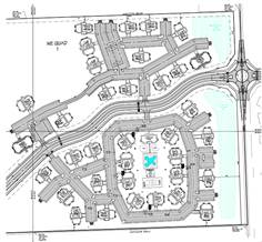
The buildings are well setback from the adjacent streets, but are located near the north and south property lines as shown in Figures 5 and 6.
The buildings on the north and south perimeter of the project will be 3 story Classic IV models. This model does not have balconies. The buildings are setback from the adjacent properties a minimum of 35 ft from the north property line and 37 ft from the south property line. No development proposals have been submitted for the property to the north but it is expected to develop as single-dwelling residential, based on the recommendations of the Northwest Area Plan. The property to the south has single-dwelling zoning and a preliminary plat has been approved, Figure 6.
Three buildings and parking areas are located along the southeastern property line, adjacent to the proposed Kellyn Addition. The nearest buildings, approximately 37 ft from the south property line, are oriented so the sides face the south. These buildings do not contain balconies and a 25 ft Type 1 Bufferyard is proposed, as required by Code. In order to minimize impact to the adjacent single-dwelling residential development, a continuous hedge or solid fence or wall should be installed in this area to screen the parking areas from the nearby residences. The height of the buildings is mitigated by the bufferyard, the 37 ft setback and the fact that the buildings are oriented so the narrow portion fronts the adjacent property.
|
B A A |
|
||||||
|
B |
|||||||
|
Figure 5. Building setbacks from the north and south property lines. |
|||||||
|
|
|
Figure 6. Relationship with proposed development to the south. |
The proposed development, as conditioned, meets the standards for a Planned Development in Section 20-701. The proposed development meets the minimum area requirement for a PD district.
Section 20-701(d) states that all of the standards of the Development Code apply to development within a PD District except as expressly authorized by regulations of Section 20-701. The dimensional standards of the RM12 District are met. The proposed density is compliant with the density restriction placed on the property with the rezoning ordinance. The parking requirements of Article 9 apply to this development and have been met. The landscaping requirements of Article 10 apply to this development. The Preliminary Development Plan shows the landscaping; however, this will be reviewed and revised, if necessary, with the Final Development Plan. The development takes access primarily to the internal street, Rock Chalk Drive, and has a secondary access point shown on George Williams Way. The bufferyard landscaping along the south property line is located within a Utility Easement. The landscaping should be pulled back from the utility easement and a wider bufferyard provided, if necessary, to accommodate the landscaping.
The proposed development, as conditioned, is compliant with the standards of the Development Code.
Staff Finding – The proposed Preliminary Development Plan is consistent with the Statement of Purpose of Planned Developments. The proposed Preliminary Development Plan, as conditioned, is consistent with the standards of Section 20-701 of the Development Code.
3) The nature and extent of the common open space in the Planned Development.
Portions of the sensitive lands which include heavily wooded areas and steep slopes will be protected and serve as common open space. The applicant’s intent is to develop an apartment complex with accessory recreational uses, such as tennis courts, swimming pool, club house, etc. These recreational amenities make up the open recreation space, and are a part of the common open space. 43.88 acres, 60.3% of the site, is being set aside as common open space and 23.8 acres, 32.7% of the site is being maintained as natural open space. The common open space provided complies with the requirements in the Development Code.
The Code requires that a minimum of 50% of the common open space be developed as recreational space unless environmentally sensitive lands are present. If environmentally sensitive lands are present the amount of Recreational Open Space may be reduced to no less than 5% if necessary to preserve natural open space. The Recreational Open Space (23.6 acres) is located in an area without environmentally sensitive lands, but makes up 50.0 % of the common open area. This allows the protection of the environmentally sensitive lands through placement in the common open area.
Staff Finding – The proposed Preliminary Development Plan will provide common open space which exceeds that required by Code.
4) The reliability of the proposals for maintenance and conservation of the common open space.
The plan notes that Links at Lawrence will own the property and will maintain the common open space. The plan notes the areas to be conserved. A note must be placed on the Preliminary Development Plan that prior to any construction activity occurring on the site, the perimeter of the wooded areas adjacent to any construction activity will be fenced at the drip line and signage will be erected which states that any construction activity, grading, trenching or storage is prohibited within the fenced area.
Staff Finding –Links at Lawrence will own and maintain the common open space. A note must be placed on the plan regarding protection measures which will be undertaken for the common open space which contains environmentally sensitive features during construction.
5) The adequacy or inadequacy of the amount and function of the common open space in terms of the densities and dwelling types proposed in the plan.
The density of the entire site is 6 dwelling units per acre; however, the 900 dwelling units will be clustered on the east and west portions of the site. The Development Code requires 50 sq. ft. of outdoor area that can be used for recreational purposes for each dwelling unit in a conventional RM12 District. The Code states that the required outdoor areas serve as an alternative to a large rear setback and is an important aspect in addressing the livability of a residential structure on a small lot. The development plan proposes 900 dwelling units. The Development Code would require 45,000 sq. ft., (900 x 50 sq. ft) or a little more than an acre, of outdoor area. This development is being designed as a planned development but the apartments are located in small areas, similar to the conventional RM12 zoning district. Where the 45,000 sq. ft. would adequately mitigate the denser development in a base district, the Preliminary Development Plan provides 48 acres of common open space. Approximately 24 acres will remain as natural open space and will provide a scenic, natural area for the site. The remainder, approximately 24 acres, will be developed with active recreation uses which will provide recreational opportunities for residents.
Staff Finding – The amount and function of the common open space is adequate based on the density of the areas being developed for residential uses. The dwelling types are apartment buildings. The amount of open space being provided exceeds that required by the Development Code in the conventional RM12 District and exceeds the open space requirement of the Planned Developments.
6) Whether the Preliminary Development Plan makes adequate provisions for public services, provides adequate control over vehicular traffic, and furthers the amenities of light and air, recreation and visual enjoyment.
The Fire Code Officials have been discussing the proposed plans with the applicant. Any changes recommended by the Fire Code Officials should be made to the Preliminary Development Plan.
Wooded areas will be conserved to provide visual enjoyment and passive recreation. The large amount of common open space will provide ample light and air. There will be several opportunities for recreational enjoyment on the site. The tennis courts, basketball courts, club house, putting green, and swimming pool are part of the common open space being provided as open recreational space. A 10 ft wide bike/rec path will be installed on one side of Rock Chalk Drive to connect with the bicycle/walking path system in the area. A pedestrian/access easement will be provided from the parkland in the Oregon Trail Addition at the southern border of the property to the northern border. A 12 ft wide rec path will be constructed with this development; however, it will not connect to the north property line at this time. The connection will occur when a trail has been developed on the property to the north. Per Section 20-810(f)(4)(iii) pedestrian easements must be a minimum of 12’ in width. This easement will be shown on the Preliminary Development Plan and will be finalized at the final plat stage.
Staff Finding – The Preliminary Development Plan’s provisions for Fire/Medical access are being discussed with the Fire Code Officials and the plan will be revised to reflect any changes recommended. The Preliminary Development Plan has made adequate provisions for public services and provides adequate control over vehicular traffic through limited access points onto Rock Chalk Drive, which is designated on the Major Thoroughfares Map as a collector street. The plan furthers the amenities of light and air, recreation and visual enjoyment through the provision of common open space, open recreation space, and other recreational facilities.
7) Whether the plan will measurably and adversely impact development or conservation of the neighborhood area by:
a) doubling or more the traffic generated by the neighborhood;
The City Transportation Planner indicated that the development would increase the traffic in the neighborhood by more than double; but pointed out that there is little development existing in the area. The residential area to the east of Queens Road and St. Margaret’s Episcopal Church to the south are the only developments in the area. Therefore, the fact that the amount of traffic generated will be more than doubled is tempered by the fact that the area is currently undeveloped.
b) proposing housing types, building heights or building massings that are incompatible with the established neighborhood pattern; or
The housing types and massings are compatible with the established neighborhood pattern. The houses located along Queens Road face away from the road, therefore this development is to their rear. The buildings proposed in this development may not be appropriate in close proximity to the other residences in the neighborhood; however, the impact of the buildings type and massing will be mitigated by the separation distance and the golf course landscaping. The buildings will be located 150 ft to 360 ft from Queens Road. A portion of the golf course will be located within this buffer area. The property is further separated from the residences by Queens Road, a collector street. The houses adjacent to Queens Road face away from the development. The impact of the building type and massing should be minimal on the neighborhood to the east.
Property to the south has been platted as a residential subdivision. Rock Chalk Drive will separate the development from the residences to the south. South of Rock Chalk Drive, where it borders the south side of the subject property, will be residences, most of which face away from Rock Chalk Drive, and City parkland. Two lots near Headwaters Drive may have their sides toward the proposed development. No buildings are planned for this area. The golf course and open space will be located north across Rock Chalk Drive. The impact of the building type and massing should be minimal on the neighborhood to the south.
The land to the west, across George Williams Way, is zoned GPI and is being planned as a sports/recreation facility for KU and the City of Lawrence. The building type and massing should have no impact on this future development.
The building type and massing should have minimal impact on the existing rural residences or on future development to the north.
c) increasing the residential density 34% or more above the density of adjacent residential properties.
The property to the north is outside the city limit and is zoned for agricultural uses, but is recommended in the Northwest Area Plan for low density residential development. The property to the east is zoned for RS7 (Single-dwelling Residential) uses with a maximum density of 6.2 units per acre. To the south is a platted subdivision, which has not yet been constructed. The properties in this subdivision are zoned for RS7 (Single-dwelling Residential), RM12 (Multi-dwelling Residential) and RM12D (Multi-dwelling Residential, duplex) uses. The densities to the south are a maximum of 6.2 and 12 units per acre. The proposed density of the Links at Lawrence development is 6 units per acre. The development will not increase the residential density above the density of adjacent residential properties.
Staff Finding-- Staff has determined that the Preliminary Development Plan will not have measurable and adverse impact on the development or conservation of the neighborhood area. The density is less or similar to surrounding residential properties and the buffering provided by the building setbacks, lakes and the open space will minimize any negative impacts the multi-dwelling structures may have on adjacent properties.
8) Whether potential adverse impacts have been mitigated to the maximum practical extent.
The parking areas’ location within the interior of the site should prevent any glare or spill-over light onto adjacent properties. A photometric plan will be required at the final development plan stage to insure there is no adverse impact from the proposed exterior lighting. The recreational facilities are located in the center of the site and should not impact the surrounding properties.
Staff Finding – Possible adverse impacts of exterior lighting will be addressed with a photometric plan to insure there is no spillover light. The location of the recreational facilities in the center of the site insulates the noise and activity from surrounding properties.
9) The sufficiency of the terms and conditions proposed to protect the interest of the public and the residents of the Planned Unit Development in the case of a plan that proposes development over a period of years.
Staff Finding- A phased development has not been proposed.
Staff Review and Conclusion
The proposed Preliminary Development Plan conforms to the anticipated land use for this area as stated in the Comprehensive Plan, and Northwest Plan and 6th & K-10/South Lawrence Trafficway Nodal Plan. The development will conserve environmentally sensitive lands while providing multi-dwelling residences at a density similar to single-family units (6 units per acre). The proposal allows the property to be utilized for residences while retaining much of the natural features on the site through the use of multi-dwelling residences (apartments) to cluster the residential development. While 20% of the site is required to be set aside as common open space with a Planned Development, the use of apartments rather than single-dwelling residences in this location allows 60% of the property to be set aside as common open space.
The amount of open space being utilized with this development and the interior location of the residential structures minimizes any negative impacts on surrounding residential properties to the north, east and south.