|
PLANNING COMMISSION REPORT Regular Agenda – Non Public Hearing Item |
|
ITEM NO. 2: ANNEXATION OF 54.31 ACRES; SURROUNDING THE FUTURE K-10 & BOB BILLINGS PARKWAY INTERCHANGE (SMS)
A-14-00155: Consider annexation of approximately 54.31 acres located surrounding the proposed K-10 & Bob Billings Parkway interchange. Submitted by Charles F. Soules, Director of Public Works, City of Lawrence for Kansas Department of Transportation, property owner of record. Initiated by City Commission on 4/22/14.
|
|
|
STAFF RECOMMENDATION: Staff recommends approval of the requested annexation [A-14-00155] of approximately 54.31 acres located surrounding the proposed K-10 & Bob Billings Parkway interchange based on the findings in the body of the staff report and forwarding this request to the City Commission with a recommendation for approval.
|
|
|
Reason for Request: |
Applicant’s response: “The City of Lawrence and Douglas County are participating in the cost of construction with KDOT for the K-10/Bob Billings Parkway Interchange. The City will be financing its share through the issuance of bonds. To issue bonds, the property and improvements must be within the City limits.” |
KEY POINTS
· The property being annexed consists of property that has been acquired by KDOT for right-of-way for the completion of K-10 Highway & Bob Billings Parkway interchange project.
· The property abuts the western city limits.
· The property is located within an area that has been identified for future urbanization in the Urban Growth Area.
· Annexation requests of more than 10 acres require a Planning Commission recommendation.
· The property is located within the Rural Water District No. 1 service area.
COMPREHENSIVE PLAN FACTORS TO CONSIDER
· The annexation request is compliant with the Growth Management and Transportation policies of the Comprehensive Plan.
ASSOCIATED CASES/OTHER ACTION REQUIRED
· There are no associated cases. Eventually this property will need to be zoned to a city designation. Rezoning can be postponed until the remainder of the corridor is annexed and the street improvements are complete. Section 20-108 (c) of the Land Development Code indicates abutting zoning district boundaries may be mapped to the centerlines of streets. There is not a separate zoning district for public street right-of-way. So eventually the zoning for most streets reflects the abutting zoning district designations.
Other action required:
· City Commission approval of annexation and adoption/publication of ordinance.
PUBLIC COMMENT
· No written public comments were received prior to the printing of this staff report.
ATTACHMENTS
· KDOT Preliminary Design Exhibit – September 2012
EXISTING CONDITIONS
|
Current Zoning and Land Use: |
A (County-Agricultural) District; agricultural uses. |
|
Surrounding Zoning and Land Use:
|
To the northeast: RM24 (Multi-Dwelling) District; vacant property/future multi-family residential in the developing Langston Commons subdivision. |
|
|
To the northwest, west and south: A (County-Agricultural) District; agricultural uses with rural residences to the southeast. To the east: RM12 (Multi-Dwelling), RS7 (Single-Dwelling), OS (Open Space) and CN2 (Neighborhood Commercial) Districts; woodland areas, with the northeast portion to be developed with commercial portion of Langston Commons. |
Site Summary
Gross Area: 54.31 acres, portions of parcels acquired by KDOT for the interchange project
Project Summary
The Kansas Department of Transportation has acquired a number of parcels in the vicinity for the completion of the K-10 and Bob Billings Parkway interchange project. The City and County are participating in the cost of construction with KDOT for this interchange improvement. The City will be financing its share through the issuance of bonds. To issue bonds, the property and improvements must be located within the city limits.
|
|
|
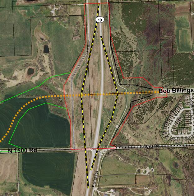
Figure 1. Proposed annexation of properties for the K-10/BBP interchange. The boundary is outlined in red. |
Annexation Procedure
Kansas Law [K.S.A. 12-519 et. seq.] provides for annexation by ordinance of the City Commission. Lawrence City policy requires the Lawrence-Douglas County Metropolitan Planning Commission to review all annexation requests in excess of ten acres. Following a recommendation from the Planning Commission, the City Commission will consider the request and adopt an ordinance.
Typically, property is rezoned to a city zoning designation following annexation. This property will be right-of-way for the street system and eventually will be zoned to reflect the abutting zoning district designations. Staff will request the City Commission initiate rezoning following completion of the street improvements.
The City of Lawrence Administrative Annexation Policy (AP-74) requires that the costs associated with compensation to a Rural Water District be paid pursuant to Kansas Statutes. The properties included in this request are located in a part of the county that is served by Rural Water District No. 1. The district has been notified of the request.
General Location
The properties requested for annexation are located west of the City limits approximately a quarter mile north and south of the proposed intersection of Bob Billings Parkway with K-10. The proposed annexation does not include all of the K-10 corridor right-of-way, but covers the area acquired for the interchange improvements. Construction is anticipated next year.
Infrastructure and Utility Extensions
The project improvements include construction of on/off ramps and a bridge over the existing K-10 highway. Future traffic signals are planned at the ramps. Improvements will include necessary utility relocations and construction of new rec trail to connect to the existing trail system. A new traffic signal will be installed by the City at the intersection of George Williams Way and Bob Billings Parkway prior to the opening of the interchange.
Public Right-of-Way: Bob Billings Parkway is classified as a principal arterial on the Thoroughfares Map. Significant right-of-way has been acquired to accommodate the trail, ramps and bridge improvements. Divided lanes with a center median will be provided east and west of the on/off ramps intersections.
COMPREHENSIVE PLAN
The subject property is located within Service Areas 1 & 3a of the Lawrence Urban Growth Area. As city services become available, properties will be encouraged to annex prior to development in these service areas. Annexation Policy No. 1 listed on page 4-5 of Horizon 2020 states that Lawrence will actively seek voluntary annexation of land within the UGA as development is proposed.
This annexation request is also considered under the Transportation Chapter of Horizon 2020 since it will accommodate the development of an expansion to the existing transportation network. Construction of this interchange with K-10 will implement land use (gateway enhancements) action steps and regional connectivity issues identified in Transportation 2040.
The annexation request is consistent with the growth management and transportation policies found in Horizon 2020.
COMPLIANCE WITH ADOPTED AREA PLANS
The subject property is located within the West of K-10 Plan. The plan indicates that urban density development should not occur until this grade-separated improvement is underway. The plan identifies the proposed improvements as a project that provides gateway opportunities and increased connection to KU. The improvements are anticipated to help relieve traffic congestion on W 6th Street.
Annexation of the area and the planned improvements provide the opportunity for improved connectivity and reduced congestion as the city continues to grow to the west. The multi-modal improvements and additional open space will provide increased recreational opportunities for citizens and visitors. These improvements comply with the goals and strategies identified in Transportation 2040.
CONCLUSION
The proposed annexation is compliant with recommendations of Horizon 2020. The subject property is located within the Lawrence Urban Growth Area and City services will be extended with the project to serve the property; therefore, annexation is appropriate.