|
PLANNING COMMISSION REPORT Regular Agenda - Public Hearing Item |
|
ITEM NO. 1 PRD [Village Meadows PRD] District TO RM15 (Multi-Dwelling Residential) District (SLD)
Z-7-20-11: Consider a request to rezone approximately 6 acres from PRD (Planned Residential Development) to RM15 (Multi-Dwelling Residential) District, located at 525 Congressional Drive. Submitted by Paul Werner Architects, for M & I Regional Properties, LLC, property owner of record.
|
|
|
STAFF RECOMMENDATION: Staff recommends approval of the request to rezone approximately 6 acres, from PRD [Village Meadows] Planned Residential Development District to RM15 (Multi-Dwelling Residential) District based on the findings presented in the staff report and forwarding it to the City Commission with a recommendation for approval. |
|
|
Reason for Request: |
The reason for this rezoning request is to provide a medium density residential transitional area between existing and proposed commercial and residential to the south, the existing commercial to the east and the existing PRD zoning to the north of Overland Drive. |
KEY POINTS
· Proposed Minor Subdivision consistent with requested zoning district boundary.
· Property originally zoned PRD-2 included as part of a 20 acre request [Z-8-30B-01] intended for multi-dwelling development.
· PRD approved with maximum density of 15 dwelling units per acre.
ASSOCIATED CASES/OTHER ACTION REQUIRED
· A-4-5-01 Annexation.
· Z-8-30B-01; A to PRD [20 acres] approved by the City Commission on 10/23/01.
· Wakarusa Place Addition original Plat.
· Preliminary Development Plan for 6Wak Apartments approved by City Commission on 3/9/04.
· PF-4-6-07; Village Meadows a replat of Wakarusa Place Addition.
· UPR-09-03-04; mixed residential including independent living units and extended care facility– expired.
· Z-7-20-11; Original Request PRD to CC200 (12.9 acres) and RM15 (5 acres)-- [Lowes]. Replaced by revised request For 6 acres PRD to RM15. [Current Request – July 2012 PC]
· MS-12-00014; Proposed Minor Subdivision to create 3 lots.
Pending Requests
· Z-12-00028; CO to CN2 1.05 acres [for portion of original 20 acres]
· Z-12-00028; PRD and CO to RM24 1.05 acres [for portion of original 20 acres]
PLANS AND STUDIES REQURIED
· Traffic Study – Not required for rezoning
· Downstream Sanitary Sewer Analysis – not required for rezoning
· Drainage Study – Not required for rezoning
· Retail Market Study – Not applicable to residential request
ATTACHMENTS
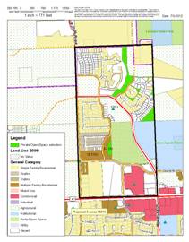
· Area Map
· Northwest Plan land use map overlay
PUBLIC COMMENT RECEIVED PRIOR TO PRINTING
· Phone calls from individuals requesting clarification on request.
Project Summary:
Proposed request is for rezoning of 6 acres from a Planned Residential District to a conventional multi-dwelling district.
1. CONFORMANCE WITH THE COMPREHENSIVE PLAN
Applicant’s Response: Horizon 2020 states, “Medium-density residential development, reflecting an overall density of 7 to 15 dwelling units per acre, is recommended as clustered development at selected locations along major roadways, near high-intensity activity areas, and when adjacent to important natural amenities. Pg- 5.4” The subject property fits Horizon 2020’s description for the appropriate location of RM15 zoning by being adjacent to existing and proposed commercial areas to the south, proposed high density residential to the south and existing commercial to the east. The open space area to the north east and the major roadways serving this area make this a great location for medium density residential.
Horizon 2020 also states, “Most of the sites recommended for new medium-density residential development occupy transitional locations between single-family neighborhoods and office/commercial areas. Some sites are recommended near large open space or natural areas. In addition to providing attractive new housing options within the city, these areas should be designed to help avoid major and abrupt changes in density or use. Existing and planned medium-density residential development is widely scattered throughout the city. Pg 5.5” Horizon 2020 does not show the subject property on the Future Land Use Map, however the proposed RM15 zoning will compliment the area and provide appropriate transition from the proposed high density zoning to the south.
Various plans address general land use area in addition to Horizon 2020. This property is within the boundary of the Northwest Plan. The 6th & Wakarusa Nodal Plan extends into the Northwest Plan boundary and terminates at the east property line of proposed RM15 request. This property is outside of the boundary of that nodal plan. Horizon 2020 supports infill development over new annexations. Approval of the request would facilitate development of this property. This area is generally described as suitable for multi-family development. The Northwest Plan supports medium density residential uses consistent with the proposed zoning.
Staff Finding – The proposed request is consistent with the land use recommendations included in the comprehensive plan.
2. ZONING AND USE OF NEARBY PROPERTY, INCLUDING OVERLAY ZONING
|
Current Zoning and Land Use: |
PRD [Village Meadows] Planned Residential Development and CO (Commercial – Office) District; undeveloped land. Maximum Density allowed for this PRD is 15 dwelling units per acre.
This request represents a portion of a larger tract subject to additional development requests.
|
|
Surrounding Zoning and Land Use: |
OS (Open Space) District and PCD [6Wak] Planned Commercial Development to the east. Wal-Mart, detention pond and vacant commercial pad sites.
RMO (Multi-Dwelling Residential-Office) District to the south. Existing apartments and vacant lot.
UR (Urban Reserve) to the west; undeveloped land
PRD [Parkwest PRD; Camson Villas east of Eisenhower, Park West Gardens, west of Eisenhower Drive, existing multi-dwelling developments
OS (Open Space) District to the north; future undeveloped park |
Staff Finding – The density of the PRD portion of the property is consistent with the proposed RM15 District. The surrounding development to the north and northwest are developed with apartment complexes. The area to the south and west is undeveloped at this time.
3. CHARACTER OF THE NEIGHBORHOOD
Applicant’s Response: The character of the neighborhood consists of medium to high density residential to the north and west with a portion of UR zoning directly west of the subject property. The area is further defined by existing and proposed commercial and residential zoning to the south and commercial to the east with open space zoning to the north east. This is a thriving residential and commercial area of Lawrence served by the surrounding collector and arterial streets.
|
|
|
|
Neighborhood Boundary |
Existing Land Use as of 2009 GIS data |
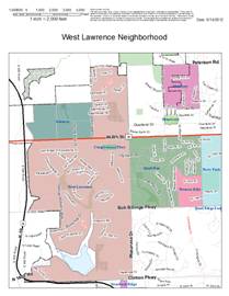
The property is located within the West Lawrence Neighborhood. This neighborhood by far is the largest in the City with more than 1,800 acres. The neighborhood includes area north and south of W 6th Street. The property is across from a 29 acre future park and within a half mile of the Lawrence Free State High School Campus. The property is also within a quarter mile of commercial uses.
The neighborhood north of W. 6th Street is dominated by residential uses. The southeast corner of the area includes commercial uses (east of Congressional Drive). Major portions of the street network have been constructed in this area with collector and arterial street designations established.
Staff Finding – The character of the neighborhood is dominated by residential uses.
4. PLANS FOR THE AREA OR NEIGHBORHOOD, AS REFLECTED IN ADOPTED AREA AND/OR SECTOR PLANS INCLUDING THE PROPERTY OR ADJOINING PROPERTY
The subject property is governed by Horizon 2020 and the Northwest Plan. The plan recommends very low density residential uses in the area that is generally north of Peterson Road. Land use intensity is recommended to transition to higher intensity uses from the north to the south with the highest intensity uses located along the arterial streets. The proposed RM15 zoning district is located on the south side of Overland Drive in the area anticipated for higher intensity development. The original approval for PRD zoning included a maximum density of 15 dwelling units per acre for the proposed Village Meadows project. This request represents 6 acres of the planned 17.8 acres. Pending zoning requests address the remaining 11.8 acres. The proposed request is consistent with the adopted plans for this area.
Staff Finding – The proposed request is consistent with the planned development in the area.
5. SUITABILITY OF SUBJECT PROPERTY FOR THE USES TO WHICH IT HAS BEEN RESTRICTED UNDER THE EXISTING ZONING REGULATIONS
Applicant’s Response: The subject property is currently zoned PRD which is allowed under the former Development Code. While the property is suitable for this zoning designation, it is also suitable for RM15 zoning. The previously approved Village Meadows UPR for a retirement facility included 310 dwelling units which would have given the site a density of 17 units per acre.
The proposed request would remove 6 acres from the existing 17.8 acre PRD. The maximum density allowed would not be altered by this request. The approved density for the Village Meadows project excluded the assisted living and Alzheimer’s units from the total calculation. The proposed RM15 district is consistent with previous approval granted for this property. The RM15 district allows attached, clustered, and multi-dwelling residential uses and permits detached housing as a Special Use in this district.
Staff Finding – The suitability for medium density residential development is not altered by this request.
6. LENGTH OF TIME SUBJECT PROPERTY HAS REMAINED VACANT AS ZONED
Applicant’s Response: The subject property has never been developed and has continued to remain vacant since it was zoned PRD.
The property is currently undeveloped. The PRD zoning was approved October 23, 2001. The zoning was contingent upon approval of a development plan which became known as Village Meadows. The associated Use Permitted upon Review [UPR-9-3-04] was approved in 2005 but expired. The current zoning has been in place since 2006 upon adoption of the Land Development Code.
Staff Finding – The property is currently vacant.
7. EXTENT TO WHICH APPROVING THE REZONING WILL DETRIMENTALLY AFFECT NEARBY PROPERTIES
Applicant’s Response: No detrimental effects will occur to nearby properties by rezoning this property to RM15 from PRD.
Approval of the rezoning modifies the development standards applicable to development of the site. Approval of the request does not significantly alter the allowed uses or density for this property. No detrimental effects are anticipated to result from approval of the proposed zoning.
Staff Finding – No detrimental effects are anticipated to result from approval of the proposed zoning.
8. THE GAIN, IF ANY, TO THE public health, safety and welfare due to the denial of the application, as compared to the hardship imposed upon the landowner, if any, as a result of denial of the application
Applicant’s Response: The gain to the public if this application were approved would be adequate buffering for the residential to the north and provide additional units within walking or short driving distance of this growing commercial area of Lawrence. The hardship of the denial of this application would be the ground would remain undeveloped and become increasingly difficult develop.
Evaluation of this criterion includes weighing the benefits to the public versus the benefit of the owners of the subject property. Benefits are measured based on anticipated impacts of the rezoning request on the public health, safety, and welfare.
Approval of the request will facilitate infill development in this area. The property abuts an existing collector street. Commercial destinations and public spaces are located east and northeast of the property. There is no anticipated “cut-through” traffic that would be generated by this development to the lower density areas to the north.
Staff Finding – There is no negative impact anticipated to result from approval of the proposed RM15 zoning.
9. Professional staff recommendation
The significant change represented by this request, other than the total area, is the change from a planned residential development to a conventional multi-family residential development. The 2006 Development Code was adopted with more detailed design standards for open space than was provided in the 1966 Zoning Code. These design standards are comparable to many of the open space requirements of a Planned Unit Development in the old Code. Approval of the request for a smaller land area and with conventional zoning will facilitate development of the area.
CONCLUSION
The proposed RM15 District is comparable to the existing density and planned land use for the area. Staff recommends approval of the rezoning of approximately 6 acres to RM15 District.